1. INTRODUCTION
Soil erosion, defined as the process of soil particle detachment, transportation by erosive agents, and accumulation in various environments such as riverbeds, is a critical environmental issue with far-reaching implications. It affects approximately 17.5% of the world’s land, with water erosion accounting for half of this area (Huang et al., 2020). Soil erosion is considered one of the primary drivers of soil degradation, with severe socio-economic impacts, including reduced agricultural productivity and increased sediment transport in rivers (Pimentel, 2006; Borrelli et al., 2018; Eekhout & Vente, 2022). The degradation primarily affects soil fertility, organic matter content, and structure, ultimately reducing crop yields. According to Pimentel (2006), soil provides approximately 99.7% of all food consumed by humans. Yet, with a global population of 8.2 billion, expected to exceed 9.5 billion by 2050, the need to address soil degradation has become increasingly urgent to meet rising food demand (Pimentel & Burgess, 2013).
Soil erosion also plays a significant role in altering sediment dynamics within river systems, increasing turbidity, solid flow, and pollutant transport, with approximately 60% of eroded soil ending up in rivers (Asselman et al., 2003; Borrelli et al., 2013; Suif et al., 2016; Chuenchum et al., 2019; Gusarov, 2021). Moreover, the erosion of the upper soil layers results in the loss of microorganisms and nutrients (Meena et al., 2017), further reducing fertility over time (Xiao et al. 2017). Beyond its impact on soil health, erosion contributes to the release of approximately 75% of stored soil carbon into the atmosphere, thereby influencing the carbon cycle (Quinton et al., 2010; Bosco et al., 2015).
Historically, soil erosion has been a natural process; however, over the past 4000 years, it has been significantly accelerated by human activities, particularly deforestation, which has had the greatest impact (Oost et al., 2012; Jenny et al., 2019). Archaeologists have linked moments of intense soil degradation to the decline of civilizations in Greece, Rome, and the Americas (Van Andel et al., 1990; Beach et al., 2006). Since the early 20th century, climate change has further exacerbated soil erosion, with a 7% increase in precipitation over land surfaces in temperate latitudes (Dore, 2005; Gabriels, 2006). In Europe, torrential rainfall is projected to increase by up to 15%, potentially amplifying erosion rates by 58% in vulnerable areas (Klik & Eitzinger, 2010).
To address this growing concern, research on soil erosion has increasingly adopted GIS-based approaches to estimate erosion rates at local and regional scales. The Revised Universal Soil Loss Equation (RUSLE) model is the most widely used framework, accounting for approximately 90% of global soil erosion studies (Borelli et al., 2018; Bircher et al., 2022). Originally developed as an improvement to the USLE model (Wischmeier, 1984), RUSLE integrates advancements such as the use of satellite-derived NDVI data to estimate the C factor (Mammari et al., 2023; Guo et al., 2023; Covasnianu & Tudose, 2013). Its simplicity and cost-effectiveness have made it a standard tool for erosion modeling, with applications ranging from South America and Asia, where erosion rates exceed 30-40 tonnes ha⁻¹ year⁻¹, to Europe and North America, where the average rate is 17 tonnes ha⁻¹ year⁻¹ (Pimentel et al., 1995; Mukanov et al., 2019).
In Romania, soil erosion research began with the works of Moțoc et al. (1975, 1979), who implemented the USLE model. Studies have highlighted the severe vulnerability of the Subcarpathians, particularly the Curvature Subcarpathians, where erosion rates often exceed 30-45 tonnes ha⁻¹ year⁻¹, leading to the formation of ravines, torrents, and landslides (Mircea et al., 2010; Arghiuș & Arghius, 2011; Patriche, 2018; 2023). Recent research has also emphasized the effectiveness of conservation measures, such as strip-cropping systems, afforestation, and the reshaping of agricultural roads, in reducing soil erosion by up to 70% (Niacsu et al., 2022; Vîrghileanu et al., 2024).
This study focuses on the Bâsca Chiojdului watershed in the Curvature Subcarpathians, one of Romania’s most erosion-prone regions where erosion rates exceed natural soil regeneration capacity. Using the RUSLE model and GIS techniques, this research aims to estimate soil erosion rates and quantify the contribution of eroded soil to sediment loads in the river on a season basis. The study also addresses the lack of quantitative data on sediment transport in the Bâsca Chiojdului basin.
2. STUDY AREA
The Bâsca Chiojdului River is a tributary of the Buzău River having a length of 32 kilometers. It is located in Romania, at the contact between the Curvature Carpathians and the Curvature Subcarpathians. In the catchment area, the altitude ranges from 240 meters to 1452 meters in the north-west mountainous area (Figure 1). From a geological point of view flysch, sandstones, clays, and marls predominate within the basin (IGR, 1968). Soils are mainly represented by cambisol (CM) and podzol (PZ), (ICPA, 1974). The land use is dominated by natural vegetation represented by nemoral, mixed, transition and conifer forests (CLC, 2018). The built-up, agricultural and fruit tree areas are second place in terms of extent.
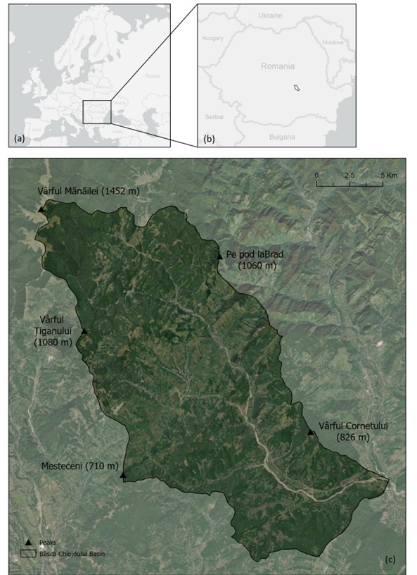
The multi-year average of monthly discharges is represented in the table below (Table 1). The highest recorded flows are typically ten times greater than the average. The three highest maximum flows were recorded in 1991 (268 m³/s), 1996 (76 m³/s), and 1998 (33.8 m³/s) (INHGA, 2023). The basin covers sub-Carpathian and Carpathian areas, with annual precipitation exceeding 1000 mm. During the summer months, usually June and July, the precipitations have a torrential regime, with a large amount falling in a short period of time, resulting in flash floods and inundations.
|
Table 1. Monthly average discharges in Bâsca Chiojdului basin (INHGA, 2023). |
|
|
Month |
Average monthly discharge (m³/s) |
|
January |
0.99 |
|
February |
1.09 |
|
March |
1.2 |
|
April |
2.29 |
|
May |
1.78 |
|
June |
2.07 |
|
July |
1.11 |
|
August |
0.73 |
|
September |
0.62 |
|
October |
0.55 |
|
November |
0.82 |
|
December |
1.13 |
3. MATERIALS AND METHODS
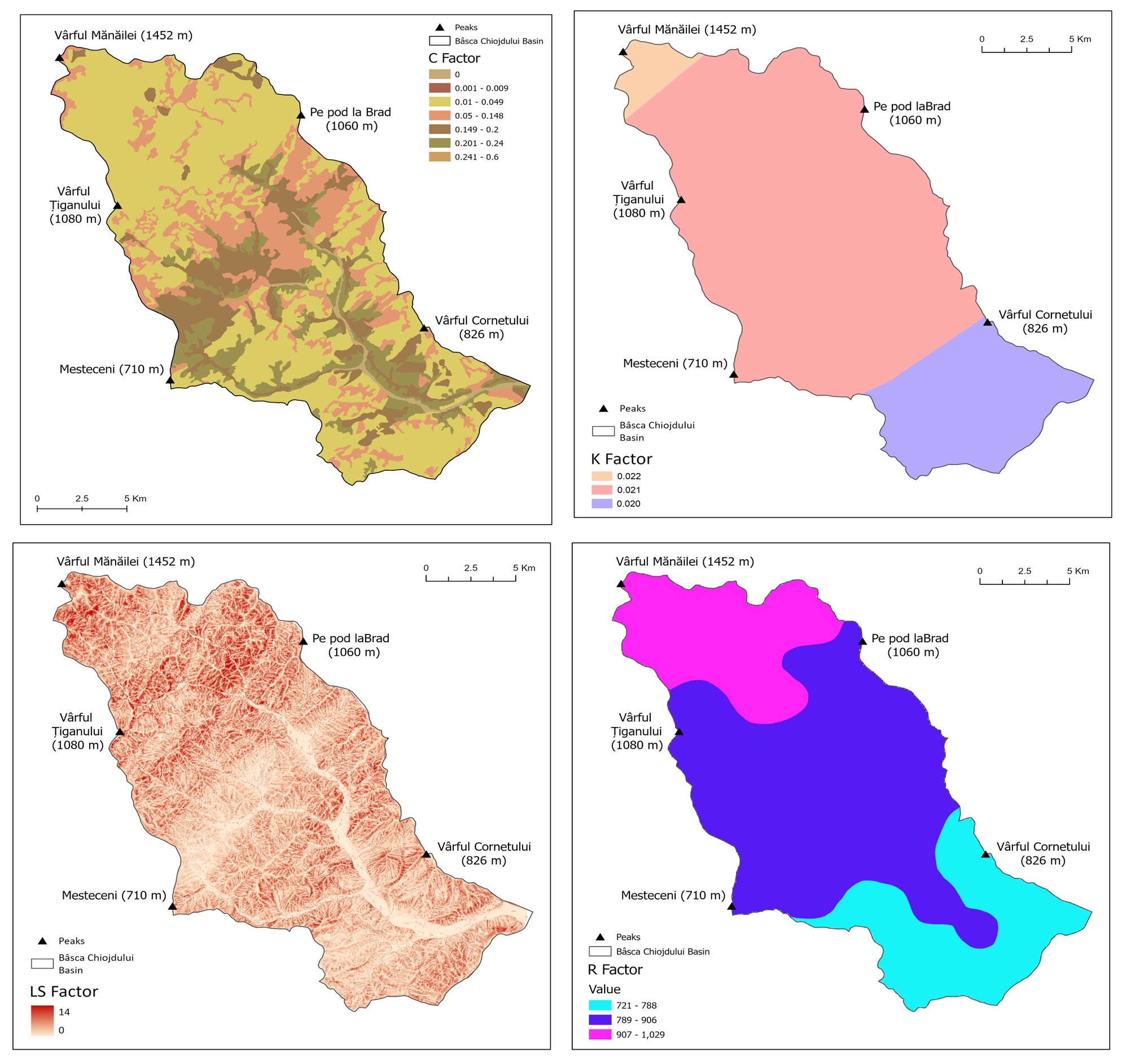
This study is based on the Revised universal soil loss equation (RUSLE) (Renard et al., 1994; Demirci & Karaburun, 2012; Ghosal & Bhattacharya, 2020) model in order to calculate the amount of eroded soil. One of the RUSLE method benefits is that it is very flexible, as it can be tailored to the specific environmental characteristics of a given area and does not involve high costs (Jahun et al., 2015; Maqsoom et al., 2020). RUSLE model uses five major factors: rainfall erosivity, soil erodibility, support practice factor, slope length and steepness, land cover and land management factor. Soil erosion is expressed in tonnes per hectare per year. The limitations of this approach include the inability to capture all the specific characteristics of the study area at a very large scale (Zhang et al., 2013; Andualem et al., 2023). Consequently, certain influential aspects of the local environment may be overlooked in the analysis.
The five factors that make up this model were computed in ArcGIS Pro at a resolution of 10 meters.

where A = mean soil loss (tonnes ha⁻ˡ year⁻ˡ), R = precipitation erosivity factor (MJ mm ha⁻ˡ year⁻ˡ), K = soil erodibility factor (tonnes ha h h⁻ˡ MJ⁻ˡ mm⁻ˡ), LS = slope length and slope steepness factor, C = land cover and management factor and P = support practice factor (Erdogan et al., 2006; Panditharathne et al., 2019).
The rainfall erosivity factor (R) represents the amount of liquid precipitation during a year and measures the erosive power of the rain based on its kinetic energy (Wischmeier & Smith, 1978; Bekele & Geml, 2021). It is highly dependent on the intensity and frequency of rainfall in a given period. The R factor takes into account precipitation that directly dislocates rock particles, resulting in various types of erosion on slopes. Through transportation, these rock particles reach and discharge into the main rivers, contributing to solid flow. In this study, the rainfall erosivity factor was determined using annual rainfall data from the National Meteorological Institute (ANM, 2008), for the period of 1961 - 2000. To calculate soil erosion by season, we used multitemporal precipitation raster data from the National Meteorological Institute. The average precipitation for each month was extracted and used in the raster calculator to multiply the layers (ANM, 2024). Furthermore, the rainfall erosivity factor was processed using equation as follows (Zhang et al., 2002):

where R = rainfall erosivity factor, P = rainfall (mm).
The main factor influencing the extent of soil erosion is the soil erodibility factor (K). It considers the physical and chemical properties of soil rocks when assessing the vulnerability of the soil layer to erosion. It takes into account four key characteristics: the fraction of sand, silt, clay, and organic matter in the soil. In general, soils that contain a higher amount of clay are more resistant to erosion, while soils that contain a higher amount of silt and sand tend to be more vulnerable (Wang & Shi, 2015). The K-factor data was taken from the World Soil Information System (Baties, 2024). The layer dataset was downloaded and uploaded in GIS programme for further processing. In the layer's attribute table, new fields were created to store information about sand (3), clay (4), organic matter (5) and silt (6):
where fsand is the fraction of sand, msilt is the fraction of silt content, mclay is the fraction of clay content, org is the fraction of organic carbon content.
The slope length and slope steepness factor (LS) (Remortel et al., 2001; Zhang et al., 2023) represents a combination of two slope particularities, slope length and the slope steepness, as erosion-controlling factors. It was calculated using the USPED (Unit Stream Power Erosion and Deposition) method (Warren et al., 2023), which uses the flow accumulation and the slope of the watershed, multiplied in ArcGIS Pro 3.2.2. To improve the model's accuracy, the resolution of the DEM was processed to 10 meters. The Fill, Flow accumulation, and Flow direction layers were created, and then multiplied using the following formulae in the raster calculator:
where L is the slope length, S is the slope steepness, A is the area of upland flow, m is 1.6, S⁰ is the slope in degrees, n is 1.3.
The land cover and management factor (C) depicts vegetation cover, which is one of the most important factors. It represents the ratio between the amount of soil lost under the influence of a certain type of vegetation and an identical area in tilled continuous fallow (Wischmeier, 1978; Zhou et al., 2008). In general forests prevent the greatest number of raindrops from falling on the canopy, protecting the soil best from erosion, whereas bare land is more vulnerable to precipitation’s kinetic energy, exacerbating erosion.
This factor was calculated using the Romanian scale land use map from (ICPA, 2018). In the attribute table assigned a C factor value to each type of land cover.
The supporting practice factor (P) represents human interventions on land use. This factor was assigned a value 1 due to lack of information.
At the end all the five factors were multiplied resulting in a map for each (Figure 2).
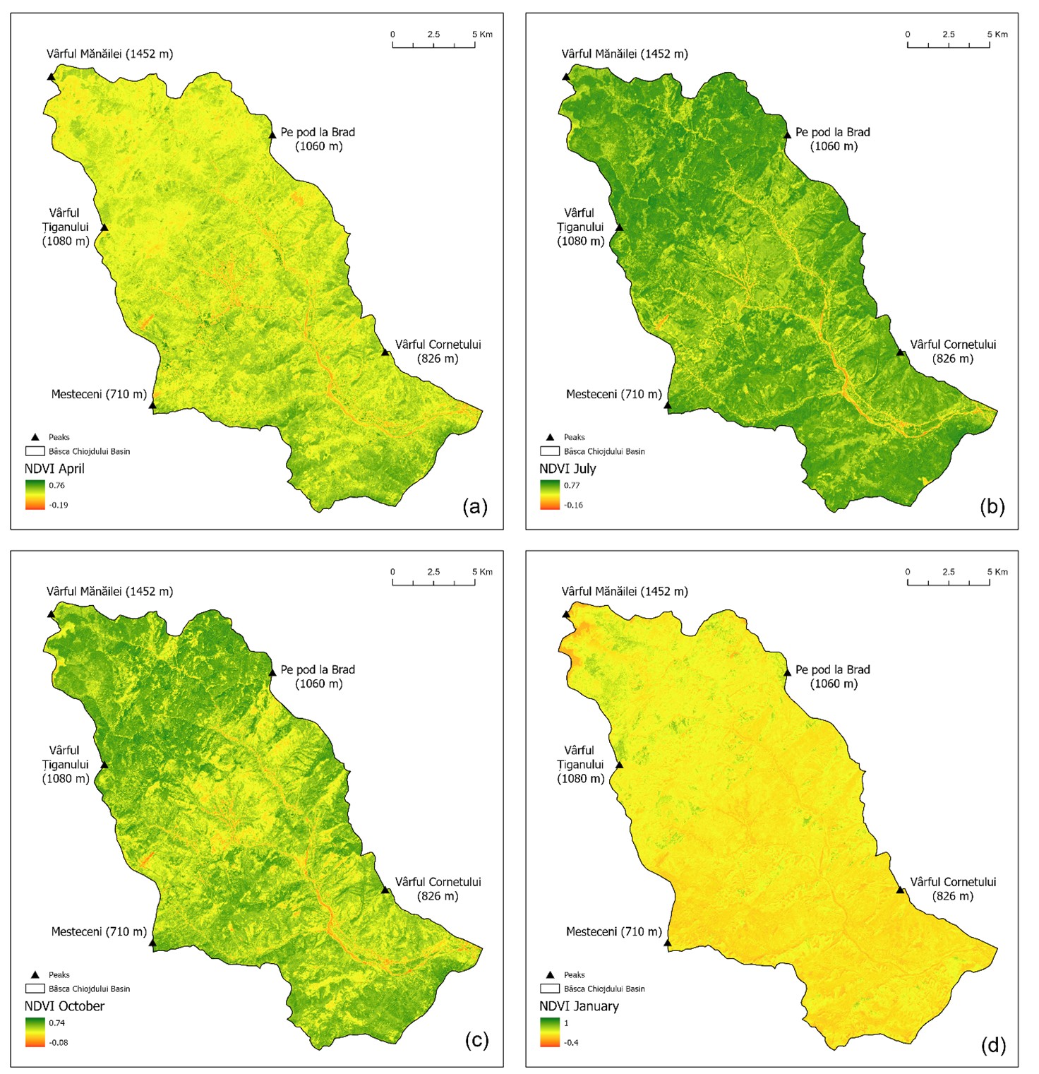
In addition to the conventional calculation method, we computed the C Factor using satellite images, from which the NDVI index was derived to determine the RUSLE model. We used 4 Sentinel 2 L2A satellite images with a resolution of 10 m, corresponding to the 4 seasons, during the year 2024. The months chosen were January, April, July and October depending on the available data without cloud cover, in the middle of the season. The NDVI was calculated in ArcGIS Pro 3.2.2 using bands 3 (red) and 4 (nearred) (Figure 3). The factor C was derived from the NDVI maps, using the formula proposed by Van der Knijff (1999), adapted for European region:

4. RESULTS AND DISCUSSION
The 5 factors, of which the P factor was considered 1 due to lack of data, were multiplied to produce the first final RUSLE map. As can be seen, the study area is mostly covered by low erosion values. The mean value of soil erosion is 9.69. The highest values of soil erosion are found mainly in the central area and following the main river channels (Figure 4).
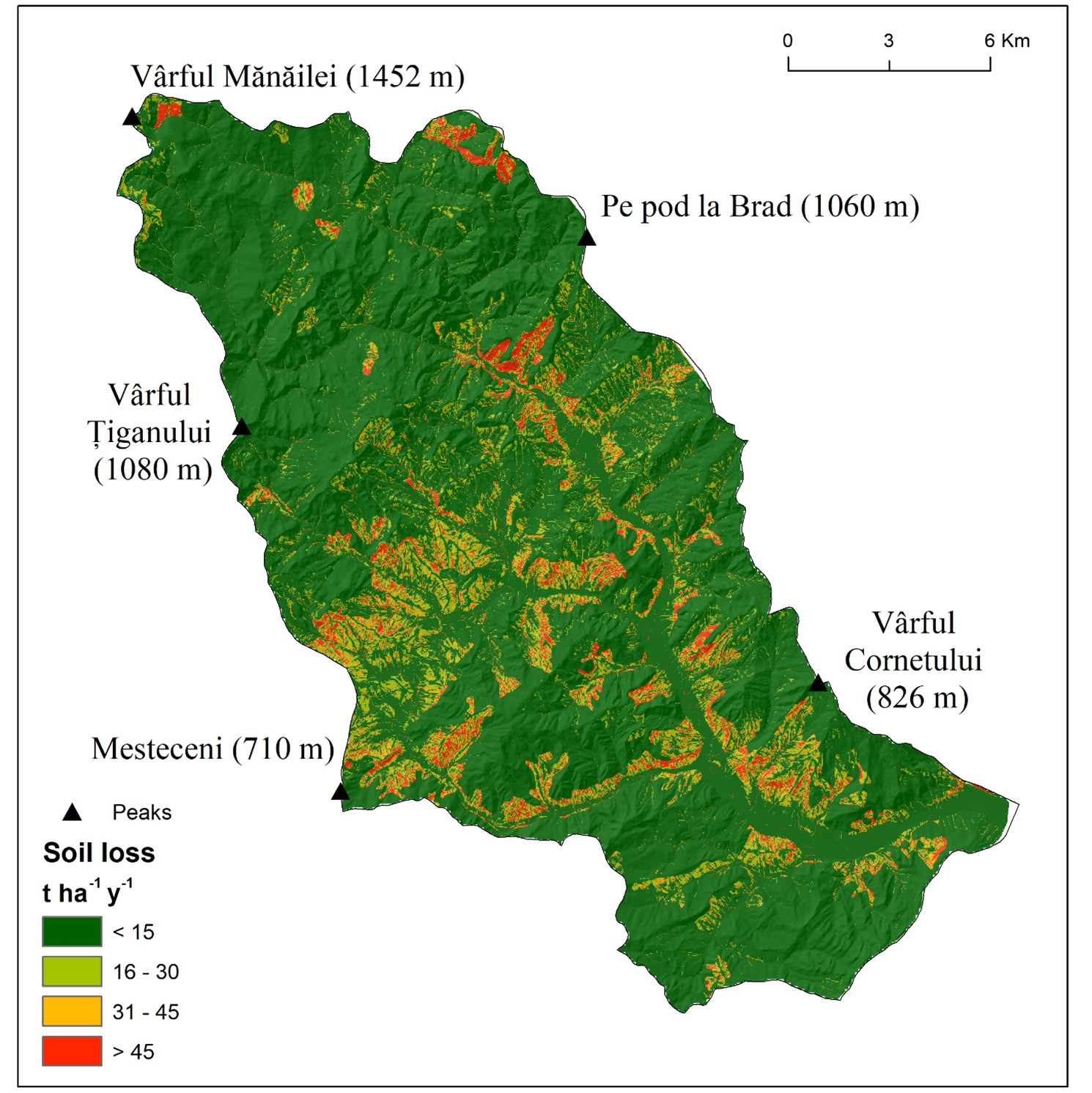
The highest values of soil erosion, ranging between 30 and 45 tonnes ha⁻ˡ year⁻ˡ, are mainly distributed in the Starchiojd - Bătrâni area, located in the central part of the basin (Figure 4). This vast area covers approximately 18 km2 with high soil erosion continuously distributed, highlighting the vulnerable nature of the region.
High erosion rates also run parallel to Bâsca Chiojdului river, along both the right and left bank, passing through the towns of Calvini, Bâscenii de Sus, Slobozia, Cătina, Chiojdu, Plescioara, Bâsca Chiojdului, Olari, Frăsinet, Slobozia and Valea Cătinei. High levels of soil erosion are also found along the Zeletin river until its confluence with Bâsca Chiojdului, meeting along the way the towns of Valea Stupinii, Bodești, Târlești, Zeletin.
In the Northen region lies a small, solitary area of about 1.7 km2 with a high soil erosion of over 45 tonnes ha⁻ˡ year⁻ˡ (Figure 4). The only human impact is represented by deforestation and the presence of forest roads.The lowest erosion rates are found mainly in the northern central and north-western areas, where the transition from the Subcarpathians to the Carpathians takes place, as well as in the south, where the slopes are fully covered in forest.
The amount of eroded material and its distribution within the basin varies according to the season, as the land cover changes according to the phenophases (Figure 5).
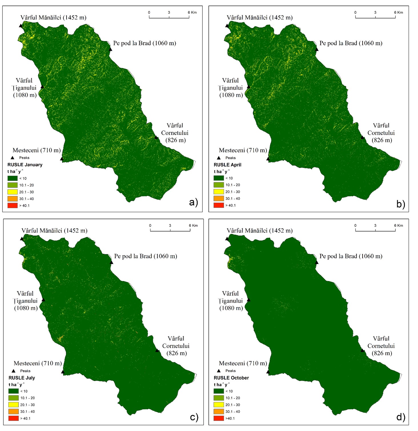
During the summer and autumn, the basin has low soil erosion rates. The high values are mainly found in the central area and Northen area, both affected by deforestation. (Figure 5c, d).
During April, when the liquid precipitation is high and the vegetation is in full transformation process, the area experiences high soil erosion rates, mainly found in the northern and central southwestern areas (Figure 5b).
During the winter, the Bâsca Chiojdului basin has high rates of soil erosion, most widespread in terms of surface area covered (Figure. 5a). During this season, the deciduous forests have lost their canopy, and precipitation reaches the ground directly, generating erosion.
Recent studies have shown that soil erosion in Europe is expected to increase by an average 18% by 2050 (Panagos et al., 2017). Romania follows a similar trajectory, with an average of 2.94 tonnes ha⁻ˡ year⁻ˡ increasing to 3.74 tonnes ha⁻ˡ year⁻ˡ in 2060 (Patriche, 2023). Therefore, studies related to soil erosion are vital to taking mitigation measures.
Soil erosion in the Bâsca Chiojdului hydrographic basin was measured using the classic RUSLE method and NDVI satellite images. The study is based on specialized literature from Europe and Romania, with the results supported by scientific articles written specifically for the Romanian territory. Previous studies (Roșca et al., 2012; Niacsu et al., 2021; Patriche, 2023; Sestras et al., 2023a) found similar estimates for soil erosion in Subcarpathian and other areas of Romania. According to Patriche (2023), who applied the RUSLE model in Romania, the values in the Subcarpathian areas range mostly between 20 and 60 tonnes ha⁻ˡ year⁻ˡ. In another paper, Sestras et al. (2023b) studied soil erosion in Cluj County, resulting values between 20 and 40 tonnes ha⁻ˡ year⁻ˡ in highter altitudes areas. Niacsu et al. (2021) applied the RUSLE model for the Racova Basin located in the central area of the Moldavian Plateau. Soil erosion values were over 35 tonnes ha⁻ˡ year⁻ˡ.
The mean soil erosion rate is 9.69 tonnes ha⁻ˡ year⁻ˡ. The maximum erosion rate over 45 tonnes ha⁻ˡ year⁻ˡ is mainly found in areas with sparse vegetation or even agricultural land. The highest erosion rates within the basin overlap with areas where the LS factor and the C factor are also high.
The high soil erosion values in the Starchiojd region come as a result of intense human activity. The areas surrounding the locality of Starchiojd have been heavily deforested for the expansion of agricultural land. The predominant rocks are sandstones, clays, marls, which are friable and prone to erosion. Being a rural area with a low economy where the land is owned by the locals for subsistence agriculture, no adequate land management measures against erosion have been taken.
The same applies to the regions of Vârful Cornetului peak, Pe pod la Brad peak, Mesteceni peak, following the Zeletin River until its confluence with Bâsca Chiojdului, Calvini, Bâscenii de Sus, Slobozia and Cătina. The slopes are being deforested, with human intervention fragmenting forest patches and making them vulnerable to rain erosion. The primary rocks are gravel, clay, marls and sand.
Unlike to the other examples, the north-eastern area is mostly covered in forest, with massive sandstones (Tarcău sandstones) making up the substrate. In this particular case the high erosion is caused by four circular deforested areas, isolated from each other, where water easily penetrates and starts the erosion process at lower altitudes.
The northen area where the transition occurs knows low rates of erosion due to low human impact, cohesive rocks (sandstone, flysch) and dense forest covering the area. Similar characteristics can also be observed in the southern region, with less anthropogenic influence, low altitudes, reduced slopes and forest vegetation covering the soil.
In contrast to previous articles, this paper includes the RUSLE seasonal model calculated using NDVI images. The resulting erosion values are consistent with those obtained in other papers that applied the RUSLE model in different areas of Romania.
In the summer when the trees crown is at its most developed, the surface of the soil is covered, protected by vegetation and therefore erosion is lower. The dense canopy of the nemoral forest prevents rainfall from direct impact. However, there are areas characterized by high erosion even in the summer season, on interfluves and slope-connected areas.
On the other hand, the erosion values are the highest during winter season, when the mainly nemoral vegetation sheds its leaves, exposing the soil to raindrop erosion. As in the previous case, the highest values are found on slopes and interfluves, where woody vegetation was previously present.
5. CONCLUSIONS
With the impact of climate change, the use of soil erosion models has become crucial to determining the intensity of erosion at the local level as well as the most affected areas. Besides the harmful effects on the soil itself, erosion also plays an important role in the river dynamics, as a quantity of sediments is transported in the channels, contributing to the solid flow. Our study has succeded to obtain quantitative data in terms of the amount of eroded soil within the basin. The main goal was to compensate for the lack of hydrological data on sediment flow in the Bâsca Chiojdului riverbed. Moreover, this study can serve to local authorities as base research to take further measures regarding better land management.
The results of this study show that the Bâsca Chiojdului watershed is mostly forested, particularly in the northern area at higher altitudes, resulting in lower soil erosion rates. The central area, Starchiojd, has the highest rates of soil erosion, 40 - 50 tonnes ha⁻ˡ year⁻ˡ, but they also occur in the southern and northern part of the basin, following the main river channels. They overlap with deforested areas, steep slopes, soft clay or marl rocks and poor land management.
REFERENCES
- Andualem, T.G., Hewa G.A., Myres B.R., Peters, S. & Boland, J., 2023. Erosion and Sediment Transport Modeling: A Systematic Review. Land, 12, 1396, https://doi.org/10.3390/land12071396.
- ANM, 2008. Clima României. National Meteorological Agency, Editura Academiei Române.
- ANM, 2024. Multidimensional raster data. National Meteorological Agency.
- Arghiuș, C. & Arghiuș V., 2011. The quantitayive estimation of the soil erosion using USLE type ROMSEN model. Case study – The Codrului Ridge and Piedmont (Romania). Carpathian Journal of Earth and Environmental Sciences, 6, 2, 59-66.
- Asselman, N., Middelkoop, H. & Dijk, P., 2003. The impact of changes in climate and land use on soil erosion, transport and deposition of suspended sediment in the River Rhine. Hydrological Processes 17, 3225–3244, DOI: 10.1002/hyp.1384.
- Baties, 2024. World Soil Information System.
- Beach, T., Dunning, N., Luzzadder-Beach, S., Cook, D. E. & Lohse, J., 2006. Impacts of the ancient Maya on soils and soil erosion in the central Maya Lowlands. Catena, 65(2), 166-178.
- Bekele, B. & Geml, Y., 2021. Soil erosion risk and sediment yield assessment with universal soil loss equation and GIS: in Dijo watershed, Rift valley Basin of Ethiopia. Modelling Earth Systems and Environment, 7, 273–291, https://doi.org/10.1007/ s40808-020-01017-z.
- Bircher, P., Liniger, H.P. & Prasuhn, V., 2022. Comparison of long-term field-measured and RUSLE-based modelled soil loss in Switzerland. Geoderma Regional, 31, e00595.
- Borrelli, P., Märker, M., Panagos, P. & Schütt, B., 2013. Modeling soil erosion and river sediment yield for an intermountain drainage basin of the Central Apennines, Italy. Catena, 114, 45-58.
- Borrelli, P., Meusburger, K., Ballabio, C., Panagos, P. & Alewell, C., 2018. Object‐oriented soil erosion modelling: A possible paradigm shift from potential to actual risk assessments in agricultural environments. Land degradation & development, 29(4), 1270-1281.
- Bosco, C., Rigo, D., Dewitte, O., Poesen, J. & Panagos, P., 2015. Modelling soil erosion at European scale: towards harmonization and reproducibility. Nat. Hazards Earth Syst. Sci., 15, 225–245, doi:10.5194/nhess-15-225-2015.
- Chuenchum, P., Xu, M. & Tang, W., 2019. Estimation of Soil Erosion and Sediment Yield in the Lancang–Mekong River Using the Modified Revised Universal Soil Loss Equation and GIS Techniques. Water, 12, 135, doi:10.3390/w12010135.
- CLC, 2018. CORINE Land Cover.
- Covasnianu, A. & Tudose, O.G., 2013. Airborne Lidar data and GIA tehnique outputs over Romanian Danube plain with special attention on geomorphology. Carpathian Journal of Earth and Environmental Sciences, 8, 1, 117 – 126.
- Demirci, A. & Karaburun, A., 2012. Estimation of soil erosion using RUSLE in a GIS framework: a case study in the Buyukcekmece Lake watershed, northwest Turkey. Environmental Earth Sciences, 66, 903-913.
- Dore, M.H.I., 2005. Climate change and changes in global precipitation patterns: What do we know? Environment International 31, 1167–1181, doi:10.1016/j.envint.2005.03.004.
- Eekhout, J. & Vente, J., 2022. Global impact of climate change on soil erosion and potential for adaptation through soil conservation. Earth-Science Reviews, 226, 103921.
- Erdogan, E.H., Erpul, G. & Bayramin, İ., 2006. Use of USLE/GIS Methodology for Predicting Soil Loss in a Semiarid Agricultural Watershed. Environmental Monitoring and Assessment, 131(1-3), 153–161. doi:10.1007/s10661-006-9464-6.
- Gabriels, D., 2006. Assessing the Modified Fournier Index and the Precipitation Concentration Index for Some European Countries. Soil Erosion in Europe, 675–684. doi:10.1002/0470859202.ch48.
- Ghosal, K. & Bhattacharya, S., 2020. A Review of RUSLE Model. Journal of the Indian Society of Remote Sensing, 48(4):689–707 https://doi.org/10.1007/s12524-019-01097-0(0123456789.
- Guo, F., Liu, X., Mamat, Z., Zhang, W., Xing, L., Wang, L., Luo, X., Wang, C. & Zhao, H., 2023. Analysis of spatiotemporal variations and influencing factors of soil erosion in the Jiangnan Hills red soil zone, China. Helyion 9, 9, e19998.
- Gusarov, A., 2021. Land use/cover change and its effect on soil erosion and river suspended sediment load in different landscape areas of European Russia during 1970–2017. Water, 13(12), 1631; https://doi.org/10.3390/w13121631.
- Huang, C., Zhou, Z., Teng, M., Wu, C. & Wang, P., 2020. Effects of climate, land use and land cover changes on soil loss in the Three Gorges Reservoir area, China. Geography and Sustainability, 1(3), 200-208.
- ICPA, 1974. Soil map. National Research and Development Institute for Pedology, Agrochemistry and Environmental Protection, Bucharest.
- ICPA, 2018. Land use map. National Research and Development Institute for Pedology, Agrochemistry and Environmental Protection, Bucharest.
- IGR, 1968. Harta Geologică a României. Institutul Geologic al României – IGR București.
- INHGA, 2023. Institutul Național de Hidrologie și Gospodărire a Apelor.
- Jahun, B. G., Ibrahim, R., Dlamini, N. S. & Musa, S. M., 2015. Review of soil erosion assessment using RUSLE model and GIS. Journal of Biology, Agriculture and Healthcare, 5(9), 36-47.
- Jenny, J.P., Koirala, S., Gregory-Eaves, I., Francus, P., Niemann, C., Ahrens, B., Brovkin, V., Baud, A., Ojala, A.E.K., Normandeau, A., Zolitschka B. & Carvalhais, N., 2019. Human and climate global-scale imprint on sediment transfer during the Holocene. Proceedings of the National Academy of Sciences, 116, 46, 22972-22976.
- Klik, A. & Eitzinger, J., 2010. Impact of climate change on soil erosion and the efficiency of soil conservation practices in Austria. The Journal of Agricultural Science, 148(5), 529-541.
- Maqsoom, A., Aslam. B., Hassan, U., Kazmi, Z.A., Sodangi, M., Tufail, R.F. & Farooq, D., 2020. Geospatial Assessment of Soil Erosion Intensity and Sediment Yield Using the Revised Universal Soil Loss Equation (RUSLE) Model. International Journal of Spatial Information, 9, 356, doi:10.3390/ijgi9060356.
- Mammari, M., Kantoush, S.A., Al-Harrasi, T.M., Al-Maktoumi, A., Abdrabo, K.I., Saber, M. & Sumi, T., 2023. Assessment of sediment yield and deposition in a dry reservoir using field observations, RUSLE and remote sensing: Wadi Assarin, Oman. Journal of Hydrology 617, 128982.
- Meena, N.K., Gautam, R., Tiwari, P. & Sharma, P., 2017. Nutrient losses in soil due to erosion. Journal of Pharmacognosy and Phytochemistry, SP1: 1009-1011.
- Mircea, S., Petrescu, N., Musat, M., Radu, A. & Sarbu, N., 2010. Soil erosion and conservation in Romania–some figures, facts and its impact on environment. Landslides, 15, 105-110.
- Moţoc, M., Munteanu, S., Băloiu, V., Stănescu, P. & Mihai, G., 1975. Soil erosion and the control methods. Ed. Ceres, Bucharest.
- Moţoc, M., Stanescu, P. & Taloescu, I., 1979. Methods for estimating total and effluent erosion on small hydrographic catchments. Bucharest, Romania: ICPA.
- Mukanov, Y., Chen, Y., Baisholanov, S., Amanambu, A.C., Issanova, G., Abenova, A., Fang, G. & Abayev, N., 2019. Estimation of annual average soil loss using the Revised Universal Soil Loss Equation (RUSLE) integrated in a Geographical Information System (GIS) of the Esil River basin (ERB), Kazakhstan. Acta Geophysica 67:921–938 https://doi.org/10.1007/s11600-019-00288-0.
- Niacsu, L., Ioniță, I., Samolia, C., Grigoraș, G. & Blebea-Apostu, A.M., 2021. Land Degradation and Soil Conservation Measures in the Moldavian Plateau, Eastern Romania: A Case Study from the Racova Catchment. Water 13(20), 2877, https://doi.org/10.3390/w13202877.
- Oost, K.V., Verstraeten, G., Doetterl, S., Notebaert, B., Wiaux, F., Broothaerts, N. & Six, J., 2012. Legacy of human-induced C erosion and burial on soil–atmosphere C exchange. Susteinability Science, 109 (47), 19492-19497, https://doi.org/10.1073/pnas.1211162109.
- Panditharathne, D.L.D., Abeysingha, Nirmanee, K.G.S. & Mallawatantri, A., 2019. Application of Revised Universal Soil Loss Equation (Rusle) Model to Assess Soil Erosion in "Kalu Ganga" River Basin in Sri Lanka. Applied and Environmental Soil Science, ID 4037379, https://doi.org/10.1155/2019/4037379.
- Panagos, P., Ballabio, C., Meusburger, K., Spinoni, J., Alewell, C. & Borrelli, P., 2017. Towards estimates of future rainfall erosivity in Europe based on REDES and WorldClim datasets. J. Hydrol. 548, 251–262, https://doi.org/10.1016/j. jhydrol.2017.03.006.
- Patriche, C.V., 2018. Quantitative assessment of rill and interrill soil erosion in Romania. Soil Use Manage, DOI: 10.1111/sum.12475 35:257–272.
- Patriche, V., 2023. Applying RUSLE for soil erosion estimation in Romania under current and future climate scenarios. Geoderma Regional, 34, e00687.
- Pimentel, D., Harvey, C., Resosudarmo, P., Sinclair, K., Kurz, D., McNair, M. & Blair, R., 1995. Environmental and Economic Costs of Soil Erosion and Conservation Benefits. Science, 267, 1117–1123, https://doi.org/10.1126/science.267.5201.1117.
- Pimentel, D., 2006. Soil Erosion: A food and environmental threat, Environment. Development and Sustainability 8: 199-137, DOI: 10.1007/s10668-005-1262-8.
- Pimentel, D. & Burgess, M., 2013. Soil erosion threatens food production. Agriculture, 3(3), 443-463.
- Quinton, J., Govers, G., Van Oost, K. & Bardgett, R.D., 2010. The impact of agricultural soil erosion on biogeochemical cycling. Nature Geoscience 3(5), 311-314.
- Remortel, R.D., Hamilton, M. & Hickey, R., 2001. Estimating the LS factor for RUSLE through iterative slope length processing of digital elevation data. Cartography, 30, 1, 27-35.
- Renard, K. G., Foster, G. R., Yoder, D. C. & McCool, D. K., 1994. RUSLE revisited: Status, questions, answers, and the future. Journal of soil and water conservation, 49(3), 213-220.
- Roșca, B., Vasiliniuc I. & Topșa, G., 2012. Models for Estimating Soil Erosion in the Middle and Lower Vasluieţ Basin. Bulletin UASVM Agriculture 69(1), 163-172.
- Sestras, P., Sevalstel, M., Roșca, S., Bilașco, Ș., Sălăgean, T., Dragomir, L., Herbei, M., Bruma, S., Sabou, C., Markovik, R. & Kader, S., 2023a. GIS based soil erosion assessment using the USLE model for efficient land management: A case study in an area with diverse pedo-geomorphological and bioclimatic characteristic. Notulae Botanicae Horti Agrobotanici Cluj-Napoca, 51, 3, 13263-13263.
- Sestras, P., Mircea, S., Cîmpeanu, S.M., Teodorescu, R., Roșca, S., Bilașco, Ș., Rusu, T., Salagean, T., Dragomir, L.O., Marković, R. & Spalević, V., 2023b. Soil Erosion Assessment Using the Intensity of Erosion and Outflow Model by Estimating Sediment Yield: Case Study in River Basins with Different Characteristics from Cluj County, Romania. Applied Science, 13(16), 9481, https://doi.org/10.3390/app13169481.
- Suif, Z., Fleifle, A., Yoshimura, C. & Saavedra, O., 2016. Spatio-temporal patterns of soil erosion and suspended sediment dynamics in the Mekong River Basin. Science of the Total Environment, 568, 933-945.
- Van Andel, T.H., Zangger, E. & Demitrack, A., 1990. Land use and soil erosion in prehistoric and historical Greece. Journal of field archaeology, 17(4), 379-396.
- Van der Knijff, J.M., Jones R.J.A. & Montanarella, L., 1999. Soil Erosion Risk Assessment in Italy. Brussels, Belgium: European Soil Bureau, European Commission.
- Vîrghileanu, M., Săvulescu, I., Mihai, B.A., Bizdadea, C.G. & Paraschiv, M.G. 2024. RUSLE‐based scenarios for sustainable soil management: Case studies from Romanian Subcarpathians. European Journal of Soil Science, 75(4), e13526.
- Warren, S.D., Ruzycki, T.S. & Zirkle, G.A., 2023. Application of the Unit Stream Power Erosion and Deposition (USPED) Model at Fort Campbell, Kentucky/Tennessee. Journal of the Kentucky Academy of Science, 83(1-2), 1-8.
- Wang, L. & Shi, Z.H., 2015. Size selectivity of eroded sediment associated with soil texture on steep slopes. Soil Science Society of America Journal 79(3), 917-929.
- Wischmeier, W.H. & Smith, D.D., 1978. Predicting rainfall erosion losses: a guide to conservation planning (No. 537). Department of Agriculture, Science and Education Administration.
- Wischmeier, W.H., 1984. The USLE: some reflections. Journal of Soil and Water Conservation, 39(2), 105-107.
- Xiao, H., Li, Z., Chang, X., Huang, J., Nie, X., Liu, C. & Jiang, J., 2017. Soil erosion-related dynamics of soil bacterial communities and microbial respiration. Applied Soil Ecology, 119, 205-213.
- Zhang, W.B., Xie, Y. & Liu, B.Y., 2002. Rainfall erosivity estimation using daily rainfall amounts. Scientia Geographica Sinica/Dili Kexue, 22(6), 711-716.
- Zhang, H., Yang, Q., Li, R., Liu, Q., Moore, D., He, P. & Geissen, V., 2013. Extension of a GIS procedure for calculating the RUSLE equation LS factor. Computers & Geosciences, 52, 177-188.
- Zhang, T., Lei, Q., Du, X., Luo, J., An, M., Fan, B., Zhao, Y., Wu, S., Ma, Y. & Liu, H., 2023. Adaptability analysis and model development of various LS-factor formulas in RUSLE model: A case study of Fengyu River Watershed, China. Geoderma 439, 116664, https://doi.org/10.1016/j.geoderma.2023.116664.
- Zhou, P., Luukkanen, O., Tokola, T. & Nieminen, J., 2008. Effect of vegetation cover on soil erosion in a mountainous watershed. Catena, 75(3), 319-325.