1. INTRODUCTION
High-altitude lakes serve as vital environmental features within the landscape, as they collect water and materials from their surrounding catchments. The unique characteristics of these systems render them highly sensitive to the impacts of anthropogenic pollution and climate change (Mosello et al., 2002; Adrian et al., 2009). Comprehensive data sets detailing the attributes of these lake-catchment systems—including geographic location, morphometry, vegetation cover and structure, soil quantity, and the geology and mineralogy of the bedrock—are essential for conducting thorough limnological studies (Berg et al., 2005; Liu et al., 2022). This information is incorporated into global databases, such as HydroATLAS, which encompasses the properties of lakes (LakeATLAS) and their respective catchments (BasinATLAS), with a specific focus on lakes with areas exceeding 10 hectares (Lehner et al., 2022).
The parameters of the Tatra Lake catchments have not yet been thoroughly determined. For instance, land cover has been assessed using planimetry based on 1:25,000 resolution aerial photographs alongside field observations (Kopáček et al., 2000, 2004a; b). According to Kopáček et al., (2000), the maps employed to verify vegetation type proportions (with scales of 1:10,000 and 1:25,000) inadequately distinguished between sparse sub-alpine meadows and bare rock, resulting in only a rough estimation of vegetation density within the catchment. They emphasized the necessity for more precise digitized terrain and vegetation models. In the research conducted by Kopáček et al., (2017), land cover characteristics were derived from aerial imagery with a spatial resolution of 0.9 m using the Iso Cluster Unsupervised Classification technique.
The delineation of catchment morphometrics was either unavailable or based on imprecise mapping (with large scale) and determinations in challenging terrain. Subsequently, these parameters were calculated mathematically. For example, the relief slope was roughly estimated by taking the difference between the maximum and minimum altitude within the catchment and dividing it by the catchment's length. This length was computed from the area of the catchment, approximated as the height of an isosceles triangle, under the assumption that high-altitude catchments generally exhibit this shape, with the lake positioned at its apex angle (Kopáček et al., 2005).
In relation to the morphometric properties of the lakes, limnological studies conducted in the Tatra Mountains draw on data collected by Gregor and Pacl (2005), which encompasses measurements taken between 1961 and 1964. These researchers emphasize that accurate data are essential for assessing the ongoing changes within the lakes and their immediate environments, which are influenced by both natural processes and environmental changes.
The rapid advancements in remote sensing (RS) and geographic information systems (GIS) are particularly suited for the detailed and precise investigation of processes and transformations within high mountain regions—such as geomorphological dynamics, vegetation patterns, and snow and ice coverage. Despite their remarkable nature, these areas often remain the "last white spots on maps" (as noted in studies of the Tatra Mountains by Falťan & Bánovský, 2004; Kaczka et al., 2015; Kapusta et al., 2018; 2021; Hrivnáková et al., 2024). However, interpreting this data can be challenging due to shading from the relief and cloud cover (Kapusta et al., 2021; Hrivnáková et al., 2024). Consequently, it is essential to complement the analysis with spatial identification and thorough field surveys accompanied by photographic documentation. Photointerpretation of lake and catchment characteristics (morphometry, land cover) based on digital orthophotos, supported by field survey, is an established method in high mountain research (Camarero et al., 2009). This approach has also been applied in the study of a comparable high mountain lake area in the Carpathians, specifically in the Retezat Mountains of Romania (Necsoiu et al., 2016).
There is an increasing demand for high-quality, accurate, and detailed statistical data and spatial maps, which are crucial for various analyses, syntheses, models, and assessments.
The objective of this study is to develop an up-to-date quantitative dataset that includes detailed geomorphometric-vegetation characteristics of 29 selected high-altitude lakes and their catchments in the High Tatra Mountains, using modern methods (RS and GIS) in combination with a field survey. Based on this dataset, the study aims to provide a comprehensive description of the nature and current status of these lake-catchment systems (in Carpathian Mountains), highlighting the anticipated differences in individual characteristics between the subalpine and alpine zones. This foundation will support further research on their impacts and changes over time.
2. MATERIALS AND METHODS
2.1. Study area
The High Tatra Mountains (49°48′-49°51′N, 19°51′-20°03′E), a geomorphological part of the Tatra Mountains (Western Carpathians), extend along the border between Poland and Slovakia. Covering an area of 341 km², it is recognized as the smallest mountain range in the world, distinguished by its typical high mountain relief shaped by glacial activity and a unique climate. The high-altitude landscape rises above the tree line, starting at approximately 1500 m above sea level and culminating at Gerlachovský štít, the Carpathians's highest peak, which stands at 2,655 m (Lukniš, 1973; Gregor & Pacl, 2005; Engel et al., 2015; Makos, 2015).
The glacial lakes found in the Tatra Mountains, known as 'pleso' (or 'staw' in Poland), represent the most recent natural formations influenced by glacial activity (Gregor & Pacl, 2005). The low permeability of the crystalline bedrock facilitates the presence of these lakes (Catalan et al., 2006). Data on the total number of Tatra lakes fluctuate due to their seasonal variations and gradual disappearance. Over 80% of the glacial lakes are located in the High Tatra Mts., attributable to the more extensive glaciation of this area. Estimates suggest there are approximately 170 to 230 lakes situated above 1300 m on the Slovak side, with the majority—over 85%—found in the high mountain region, particularly within the alpine zone at elevations of 1800 to 2200 m (Gregor & Pacl, 2005; SLS, 2012; Kapusta et al., 2018; 2021; Kopáček et al., 2019).
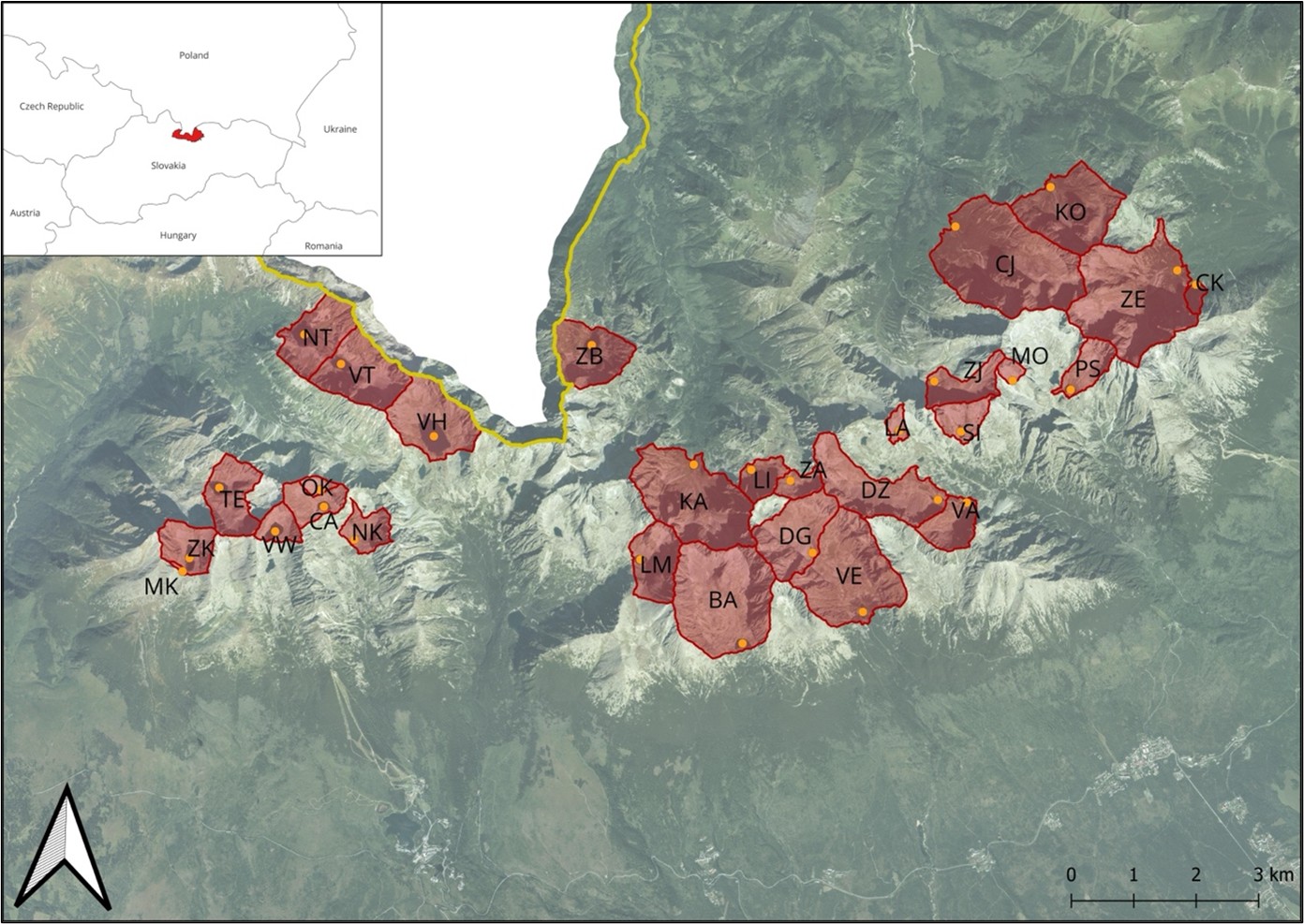
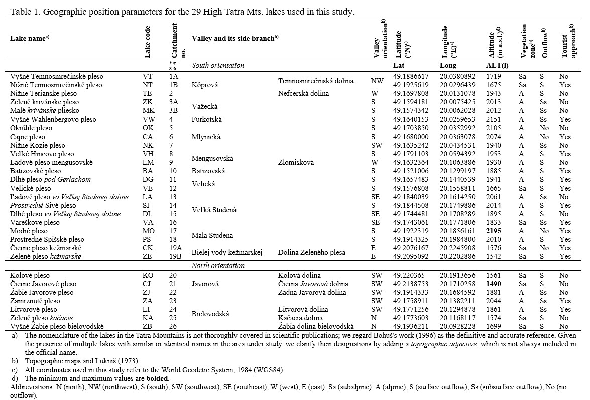
The study area is part of a broader investigation that examines the spatiotemporal dynamics of geomorphological processes in catchments and their effects on the lakes within the High Tatra Mountains (Hreško et al., 2012; 2013; 2022; Hrivnáková et al., 2023; Čajková et al., 2024). A total of 29 lake sites and their respective catchments are analysed (see Figure 1 and 2), situated across 12 valleys above the forest line (elevations ranging from 1490 to 2159 m a.s.l.). Among these, 10 lakes are located in the subalpine zone and 19 in the alpine zone (Table 1).
2.2. Delineation of lakes and their catchment areas
A digital elevation model (DEM) with a resolution of 1 m x 1 m, derived from airborne laser scanning data using Light Detection and Ranging (LIDAR) technology from 2022, was utilized to delineate the study area. This DEM was provided by the Research Institute of Geodesy and Cartography in Bratislava. By employing the ArcHydro tools within the ArcMap environment, we accurately defined the boundaries of the lakes and their catchments, for which we computed specific characteristics using zonal statistics.
2.3. Morphometric and statistical analyses in ArcGIS and QGIS
The morphometric analysis produced various parameters for lakes, including area, perimeter, length, width, and their ratios, as well as for catchments, encompassing area, ratio to lake, altitude, elevation, and length. This was conducted within the ArcMap 10.8.1 environment. The slope and aspect of the catchments were calculated using the Spatial Analyst tools, and the resulting data was saved in raster format.
2.4. Identification and mapping of land cover structure
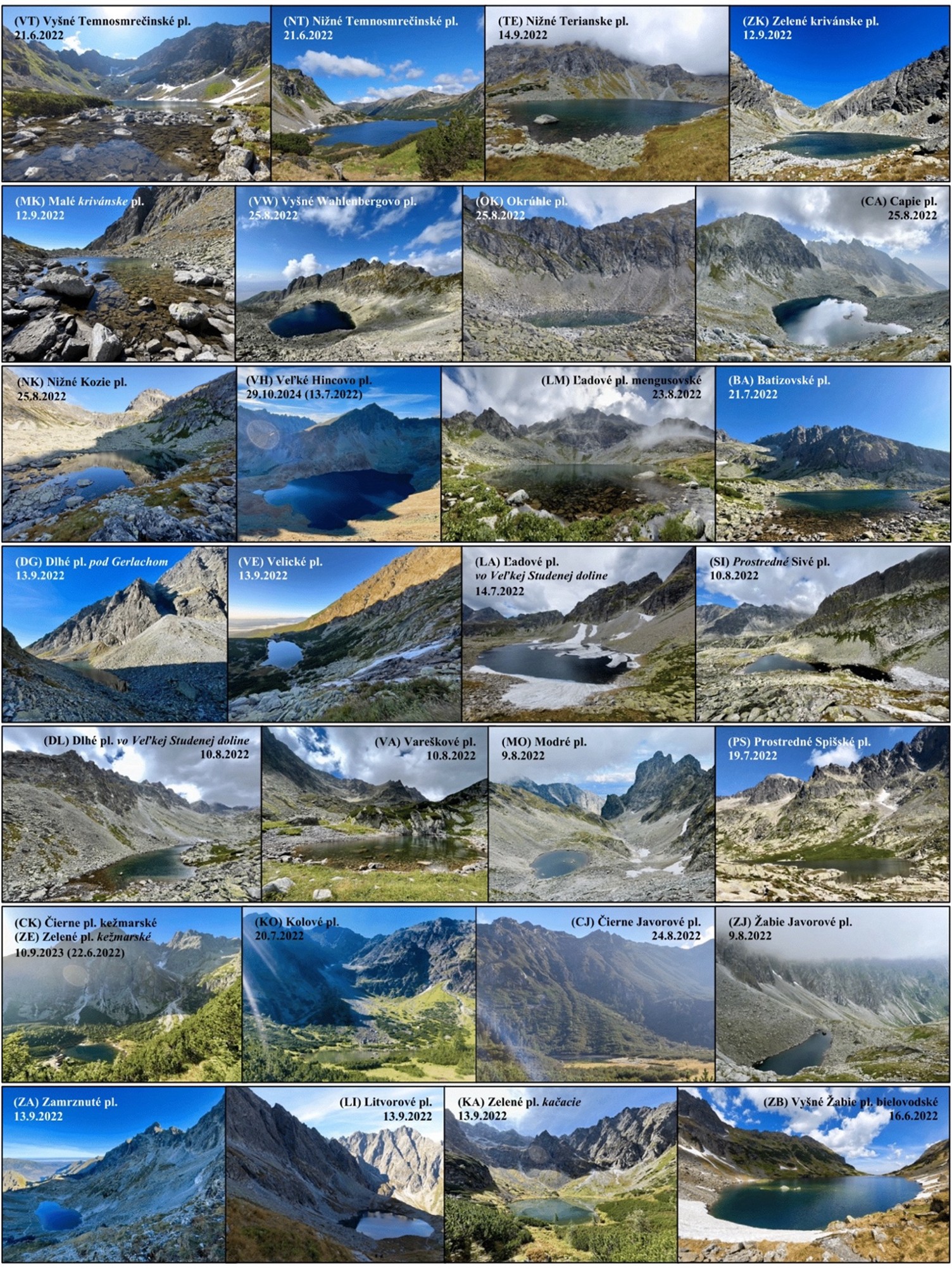
Field survey of the area: The surveyed locations are situated in rugged high-altitude terrain, with approximately half of them being accessible via hiking trails leading to the lakes (see Table 1). During the summer season of 2022, comprehensive field surveys were conducted at these study sites from June to September. The focus was on the spatial differentiation of land cover classes and the assessment of geomorphological processes to verify the accuracy of the existing orthophoto data. The catchments under study were documented through photography, with a selection of this documentation included in Figure 1. The field research was conducted by the Decision from the District Office in Prešov (Slovak republic) - Department of Environmental Protection (OU-PO-OSZP1-2021/025831-006/SJ) and under the Agreement with the Administration of the Tatra National Park (ZML-2022/1-788.191006), which provided the necessary exemption for the research of the Tatra lakes.
Remote sensing of the area: For accurate mapping and analysis of land cover, aerial images from 2022, featuring a resolution of 20 cm/pixel, were obtained from the Geodetic and Cartographic Institute in Bratislava (GKÚ). Land cover features were identified through image interpretation and manual vectorization within the QGIS 3.28.7 environment. The percentage contribution of each landscape feature to the area of the specified catchments was subsequently calculated.
The result is a vector layer representing 29 catchments, encompassing 10 land cover elements based on the CORINE (Coordination of Information on the Environment) nomenclature. The land cover categories include: (1.4.2) Leisure facilities: high-mountain huts and hotel objects, (3.1.2) Coniferous trees with discontinuous canopy, (3.2.1) Sub-Alpine grasslands: meadows without trees or shrubs, (3.2.2) Dwarf pine, (3.3.2) Rock walls and rocks, (3.3.2) Debris screes, (3.3.2) Debris flows, (3.3.5) Snow fields: snow and firn fields, (5.1.1) Water streams, and (5.1.2) Water bodies. All classes represent areas except water streams, which have a linear character.
The identified vegetation structure types provide data regarding soil quantities in the catchments (Kopáček et al., 1995). Vegetation cover serves as an indicator of soil cover extent (Camarero et al., 2009). For subsequent analyses and relationships, the cumulative area of land cover elements—including coniferous trees, sub-alpine grasslands, and dwarf pine stands—is referred to as the area with soil cover, as described by Kopáček et al. (2004a; b). Additionally, the total area of rock walls, rocks, debris scree, and flows is categorized as the area with rocks and screes cover, as these areas contain only mosaically distributed, shallow soils.
2.5. Determination of bedrock geology and mineralogy
The bedrock properties of the investigated sites were determined based on the 1:50,000 geological map ŠGÚDŠ (2017).
2.6. Further (statistical) analyses
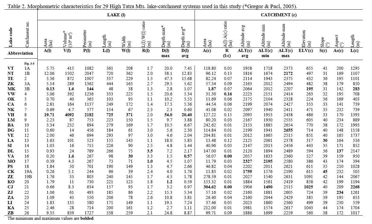
The 35 attributes gathered from the study sites were organized into five distinct categories, which were subsequently analysed statistically: (1) Geographic location and characteristics of the lakes (Table 1), (2) Morphometric characteristics of the lakes (Table 2), (3) Morphometric characteristics of the catchments (Table 2 and Figures 3, 4, 5), (4) Land cover of the catchments (Table 3 and Figure 6), (5) Geology and mineralogy of the bedrock in the catchments (Table 3).
In the results of this study, we utilize these categories to compare and characterize lakes and their catchments within both the subalpine and alpine zones, as well as to explore sites with southern and northern orientations partially.
To select appropriate analytical procedures, we conducted normality tests using the Shapiro-Wilk test and Outlier test to identify any anomalies within the dataset. Descriptive statistics were employed to summarize and characterize the lakes and their catchments, highlighting differences across vegetation zones and orientations. To evaluate the relationships between individual attributes and altitude, we performed Spearman's correlation analysis along with a permutation test of significance. Significant linear and exponential relationships were graphically represented through regression analysis. The statistical tools utilized for these analyses included MS Excel (2024) and PAST statistical software version 5.0.1 (2024).
3. RESULTS AND DISCUSSION
3.1. A dataset of characteristics from 29 sites
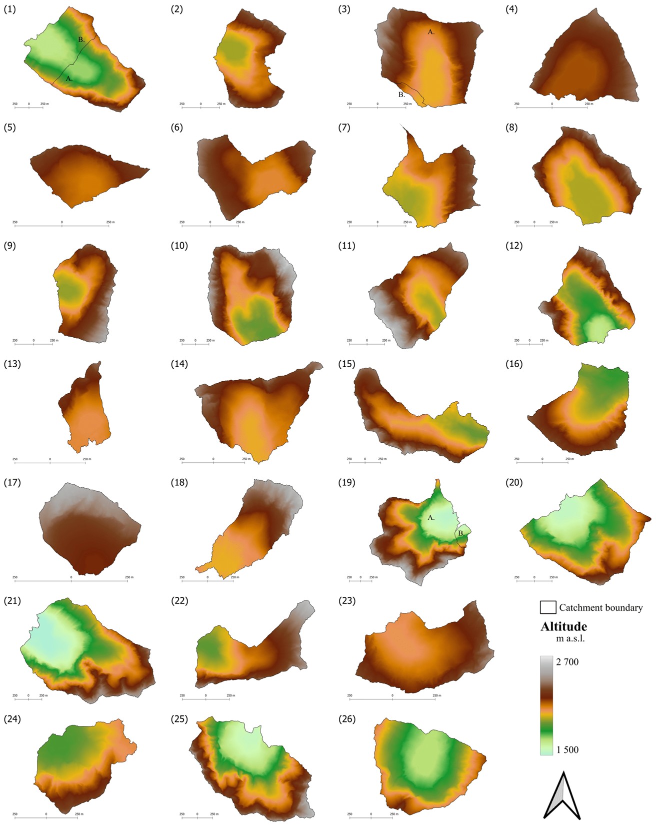
The selected morphometric characteristics of the individual lakes and their corresponding catchments are detailed in Table 2. Figures 4 through 5 illustrate the spatial variation in elevation, relief slope, and relief aspect across these catchments. Additionally, the areal extent (depicted graphically in Figure 6) and the percentages of land cover features, soil cover, as well as rock and scree cover within each study catchment are provided in Table 3. This table also includes information on the bedrock geology and mineralogy of the catchments. To better complete the picture of the character of the study sites, field survey photographs from the summer 2022 field season are included in Figure 1.
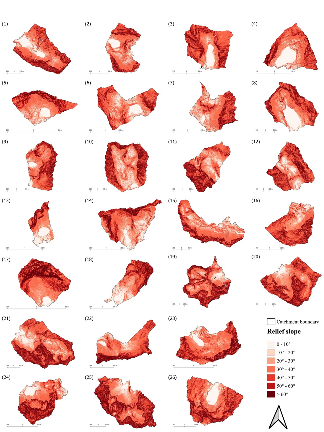
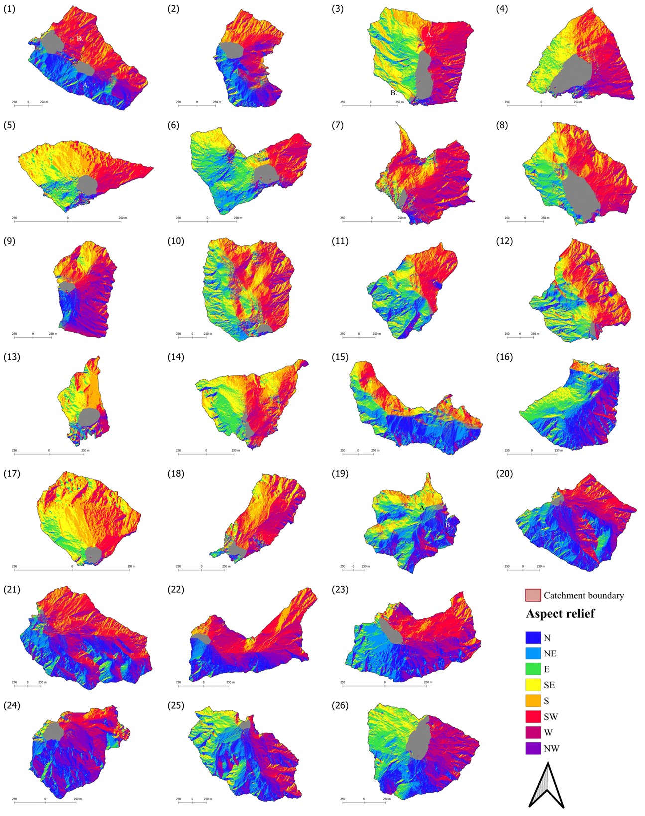
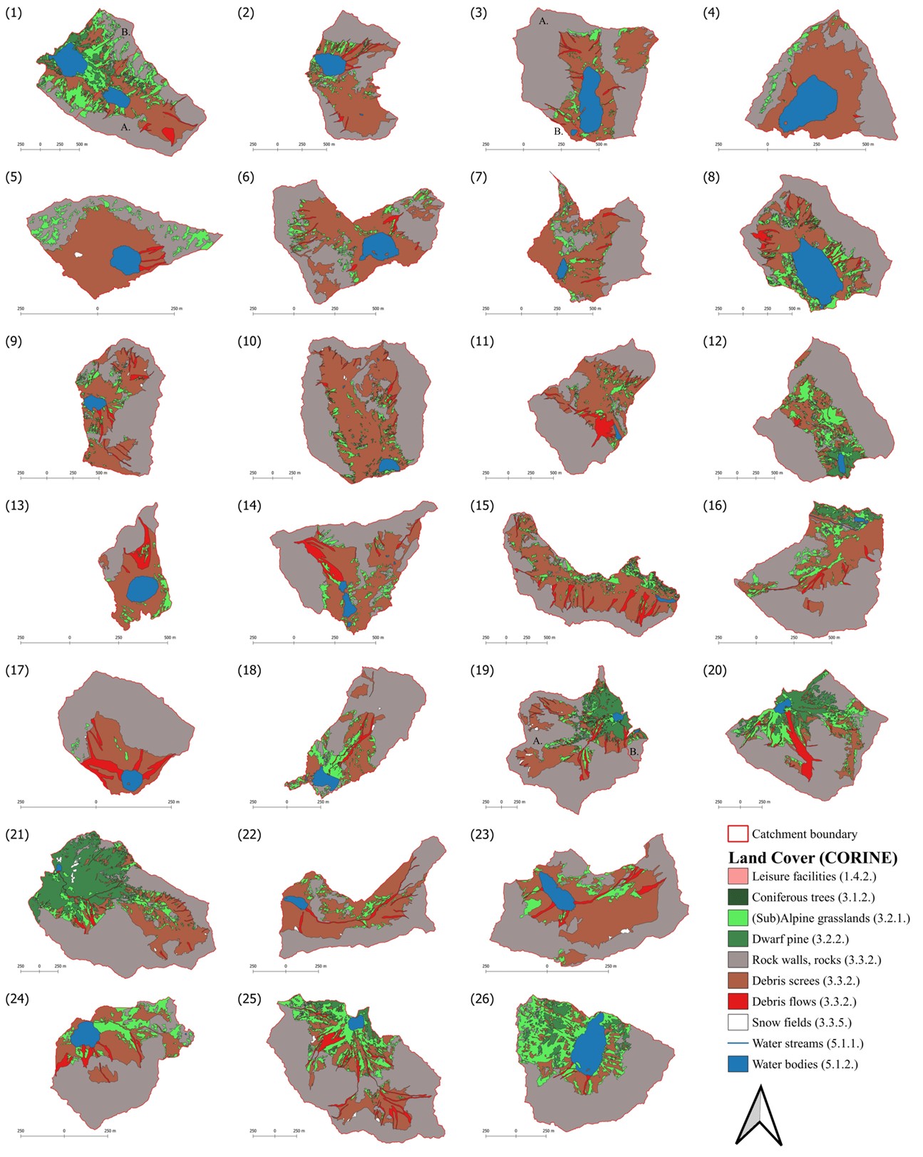
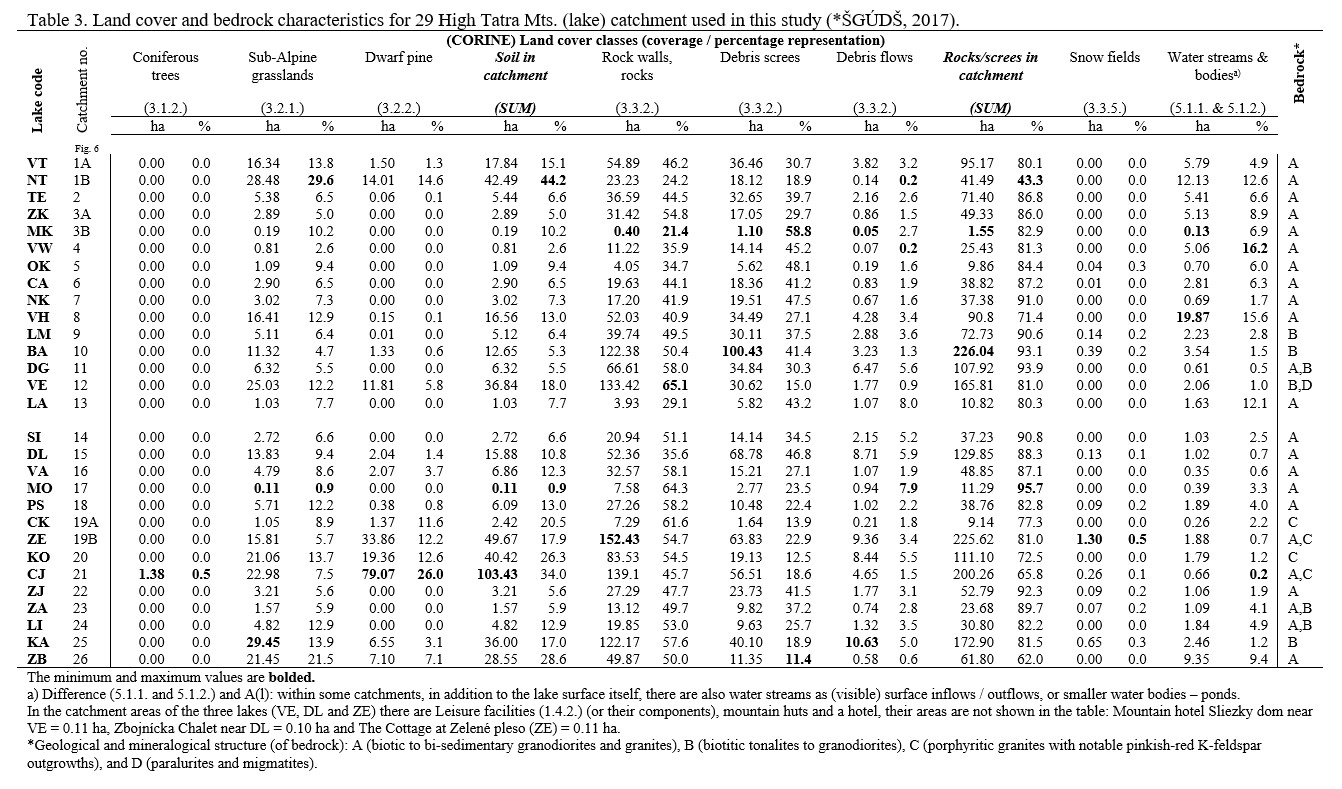
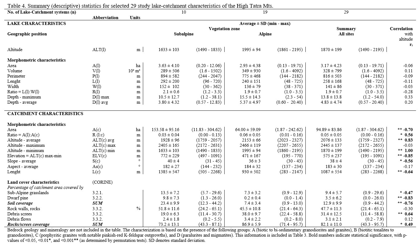
Table 4 summarizes the results of the descriptive statistics regarding the characteristics of the lakes and their catchments derived from these datasets. Building on this information, the following section explores the nature of the high-altitude lake-catchment systems in the High Tatra Mountains and their relationship with the altitude gradient, as well as the differences between subalpine (n=10) and alpine (n=19) sites.
3.2. The nature of high-altitude lake-catchment systems
The high-altitude numerous lake area of the High Tatra Mountains (Gregor & Pacl, 2005; SLS, 2012), features the subalpine zone, which ranges from approximately 1500 m a.s.l. (the lowest studied lake, ČJ, is at 1490 m a.s.l.) to about 1850 m a.s.l. (the highest studied lake, VA, is at 1833 m a.s.l.). Ascending from this boundary (with the lowest studied lake, LI, at 1861 m a.s.l.) to around 2400 m a.s.l. (where the highest studied lake, MO, reaches 2195 m a.s.l.), the alpine zone is encountered. The upper sections of the catchments extend into the subnival zone. The highest point in the High Tatra Mts. and Slovakia, the peak Gerlachovský štít, rises to 2655 m a.s.l., representing as the maximum altitude for catchment of the studied lake Dlhé pleso pod Gerlachom (DG) (Tables 1, 4, and Figure 3) (Moravec, 1992; Škvarenina & Fleischer, 2013). Due to the asymmetric uplift of the mountain range, the lakes on the northern side are found at lower elevations (~185 m). This topographical difference shapes their characteristics and also influences the nature of their catchments (Table 2, Figure 1) (Lukniš, 1973; SLS, 2012).
From a global perspective, these water bodies are relatively small, with an average area of 3.17 ± 4.23 hectares. The largest and deepest lake among those studied is Veľké Hincovo pleso (VH), which spans an area of 20.4 hectares and reaches a depth of 54.0 meters. This lake is noted for being the largest and deepest natural lake in Slovakia and within the Slovak side of the High Tatra Mountains (Tables 2, 4, and Figure 1) (Gregor & Pacl, 2005). However, the majority of these water bodies are small, often seasonal, with areas below approximately 1 hectare and depths up to around 2 meters. Despite their size, they hold significant ecological value (Gregor & Pacl, 2005; SLS, 2012; Hamerlík et al., 2014). Additionally, these smaller lakes are more susceptible to anthropogenic and climatic influences (Kopáček & Stuchlík, 1994; Svitok et al., 2021).
The observed morphometric characteristics of the lakes indicate the influence of glacial processes in their formation (Hreško et al., 2012). In the subalpine zone, the water surfaces of lakes, formed by the obstruction of outflowing water due to moraine deposits of glaciers, are larger (3.63 ± 4.10 ha). Additionally, their coastal lithological zones are more rugged, with an aspect ratio of 2.1 ± 0.6 (Lukniš, 1973; Gregor & Pacl, 2005; SLS, 2012; Kłapyta et al., 2016), predominantly consisting of gravel and pebbles, as noted in field observations (Hamerlik & Bitušík, 2009). The volume of these lakes is relatively small, measuring 289.103 ± 506.103 m³, with an average maximum depth of 10.5 ± 12.7 m, and an average depth of 3.80 ± 4.32 m (Tables 2, 4 and Figure 1). Higher-elevation lakes in the alpine zone tend to be smaller water bodies (2.93 ± 4.38 ha) with simple shapes, either round or elliptical (aspect ratio 1.9 ± 0.7). Their basins, formed in glacially created kettles, drop steeply, making them more voluminous (349.103 ± 930.103 m³) and deeper (with an average maximum depth of 15.5 ± 14.3 m and an average depth of 5.37 ± 4.97 m). The nearshore areas of these lakes are shallow and relatively undeveloped (Tables 1, 4 and Figure 1) (Lukniš, 1973; Gregor & Pacl, 2005; SLS, 2012; Kłapyta et al., 2016).
The studied alpine lakes Okrúhle pleso (OK), Modré pleso (MO), and Ľadové pleso vo Veľkej Studenej doline (LA) serve as typical examples, characterized by their nearly perfect round shape (aspect ratio 1:1). Despite their relatively modest surface areas—0.70 ha, 0.39 ha, and 1.63 ha, respectively—these lakes are notably deep, with maximum depths of 10.2 m, 4.5 m, and 18 m. In contrast, the subalpine lakes Kolové pleso (KO) and Zelené pleso kačacie (KA) are shallow, recording maximum depths of just 1.2 m and 2.7 m. However, they are larger at 1.79 ha and 2.46 ha, respectively (Table 2 and Figure 1). The numerous geomorphological processes occurring in this mountain range, which have been active since de-glaciation and are influenced by contemporary climate change, play a crucial role in the siltation of these lakes due to materials washed in from their surrounding catchments (Hreško et al., 2012; 2013; 2022; Kapusta et al., 2010; 2021). These processes contribute not only to the gradual filling of the lake basins but also to altering their shapes. For instance, the elongated forms of lakes Dlhé pleso (DG and DL) and Žabie Javorové pleso (ZJ) are attributed to significant silting occurring from one side (refer to Figures 1, 6) (Lukniš, 1973; Čajková et al., 2022; 2024).
The relief and lake catchments of the High Tatra high-altitude region are characterized by steep slopes averaging 38 ± 4°, along with substantial elevation changes averaging 575 ± 237 m (Tables 2, 4, and Figures 3, 4). This area is predominantly composed of rocky ridges and blocks, which account for approximately 47.7 ± 11.3% of the landscape, ranging from 21.4% to 65.1% at studied lakes (Tables 3, 4, and Figures 1, 6) (Lukniš, 1973; Nemčok et al., 1994; Zasadni & Kłapyta, 2009). The only vegetation present consists of bryophytes and lichens (dominated by Rhizocarpon species, Acarospora oxytona and Dermatocarpon luridum) (Voluščuk, 1994; Křeček et al., 2006; Škvarenina & Fleischer, 2013).
The geological bedrock of most lakes in the Tatra Mountains is primarily composed of low-permeability rocks, which contribute to their prevalence (Catalan et al., 2006). The geology in the study area is characterized by biotic to bi-sedimentary granodiorites and granites across 23 study catchments. In the eastern region, porphyritic granites with distinct pinkish-red K-feldspar outgrowths are observed in the catchments of CK, ZE, CJ, and KO (Table 3). Additionally, a minor presence of paragneiss and migmatites was recorded in the catchment of lake Velické pleso (Table 3) (Nemčok et al., 1994; Bezák & Majcin, 2013). The granitic massif is extensively fractured by fault zones, resulting in various types of screes and debris flows, which we have also identified within the studied lake catchments (Table 3 and Figure 6).
Extensive debris screes and flows are prevalent beneath the rock walls, in saddles, and gullies. Debris screes comprise 31.4 ± 12.5% of the studied catchment area, ranging from 11.4 to 58.8%, while debris flows account for 3.1 ± 2.1%, with a range of 0.2 to 8.0% (Tables 3, 4 and Figure 6). These formations are composed of sharp-edged materials, typically the size of gravel, with boulders being a rarer occurrence. The coarsest materials are located in the lower sections of the catchments due to gravitational influences, as confirmed in the field (Figure 1) (Bezák & Majcin, 2013). Among the most enormous recorded debris cones are those found within the catchments of the studied lakes, previously mentioned in the context of morphodynamic processes. Noteworthy examples include a 430 m long debris cone terminating at the shore of the shallow lake Kolové pleso (KO) and an 800 m long cone—originating in the Krčmárovový zľab couloir and ending at the Dlhé pleso pod Gerlachom (DG)—which accounts for its elongated shape (Figures 1 and 6) (Lukniš, 1973; Čajková et al., 2022; 2024).
Beneath these extensive relief-forming processes, a layer of poorly developed soils, primarily lithosols, and rankers with an acidic reaction and minimal organic carbon, is only mosaically distributed, measuring less than 3 cm in thickness (Kopáček et al., 2006; Kaňa et al., 2023).
Vegetation, and consequently coarser soil cover, is notably scarce in the High Tatra Mountains (Tables 3, 4, and Figures 1, 6) (12.9 ± 9.9%, with values ranging from 0.9% to 44.2% of the studied catchments area). Above the upper forest line, dwarf pine (Pinus mugo) predominates (Voluščuk, 1994; Škvarenina & Fleischer, 2013), accounting for 3.5 ± 6.2% (from 0.0% to 26.0% of the studied catchments area). More extensive complexes of sub-alpine grasslands occur on floodplain cones and near water streams and lakes, where the substrate is more conducive to growth (Boltižiar, 2007), representing 9.4 ± 5.7% (ranging from 0.9% to 29.6% of the studied catchments area). These meadows are primarily composed of grassland communities, including Juncetalis trifidi, Festuca picturata, Luzula alpinopilosa, and Calamagrostis villosa, along with sparse stands of pioneer plant species. Trees are mainly absent in the high mountain region, with only occasional spruces recorded (0.5%, found exclusively in the lake Čierne Javorové pleso catchment - Table 3 and Figure 6), as well as rowan (Sorbus aucuparia) and Silesian willow (Salix silesiaca) (Voluščuk, 1994; Křeček et al., 2006; Škvarenina & Fleischer, 2013).
Beneath these landscape features lies a coarser soil layer, ranging from 0.1 to 0.84 m in depth (with a diameter of 0.45 m). This layer comprises poorly developed podzols, leptosols and regosols, which exhibit an acidic reaction but contain a higher organic carbon content (Kopáček et al., 2006; Kaňa et al., 2023).
Due to the low nutrient availability resulting from inadequate contributions from the substrate and surrounding catchments, combined with minimal vegetation and soil coverage, we classify high mountain lakes as oligotrophic (Sommaruga et al., 1999) and dimictic, particularly those deeper than 4 m — as indicated in Tables 2 and 4 (Kopáček et al., 2019).
The proportion of cover formed by rocks and screes increases significantly (p < 0.01). In contrast, soil cover diminishes (p < 0.001) with increasing altitude in the High Tatra Mountains region, as shown in Table 4 and Figure 7 (Křeček et al., 2006; Krno et al., 2006).
![Figure 7. Relationships for study High Tatra Mts. lake-catchment systems (n=29) between percentage catchment cover with (a) soil (underlying Coniferous trees, Sub-Alpine grasslands and Dwarf pine) (picture of the subalpine lake KA) and (b) rock / scree areas (picture of the alpine lake OK) versus lake altitude [m]. Solid lines show regressions, R2 is the coefficient of determination, both relationships are significant (p < 0.01*; p < 0.001**).](/upload/images/1080/Picture7.jpg)
The catchments of lower lakes in the subalpine zone exhibit larger sizes (153.58 ± 95.16 ha) and greater lengths (1385 ± 547 m), characterized by more complex shapes and a higher area-to-lake area ratio (0.03 ± 0.04) (Tables 2, 4, and Figure 1) (Kamenik et al., 2001). This region also has a greater percentage of dwarf pine vegetation, averaging 9.8 ± 7.3%, which varies from 1.3% to 26.0% of the studied catchments area, alongside sub-alpine grasslands that constitute 13.5 ± 7.2%, with a range of 5.7% to 29.6% of the area examined. Consequently, there is a more consistent and coarser soil cover, comprising 23.4 ± 9.9%, with a similar range of 5.7% to 29.6% of the studied catchments area (Table 3 and Figure 6) (Krno et al., 2006). This soil cover serves as a stabilizing factor for slopes (Boltižiar, 2007; Kopáček et al., 2017).
The cover composed of rocks and debris remains significant, accounting for 73.2 ± 13.1% of the surveyed catchments areas, with values ranging from 43.3% to 87.1% (Tables 3, 4, and Figure 6). This indicates the presence of morphodynamic processes, where water-gravity dynamics are predominant, particularly due to the greater number of surface tributaries associated with these types of lakes (Table 1) (Hreško et al., 2013). In contrast, the catchments of higher alpine lakes situated within karst formations are generally smaller, averaging 64.00 ± 59.09 hectares, possess shorter lengths with a simpler morphology (930 ± 502 m), and exhibit a more balanced area-to-lake ratio (0.06 ± 0.05) (Tables 2, 4, and Figure 1) (Kamenik et al., 2001). The typical steep high mountain terrain (Lukniš 1973; Nemčok et al., 1994; Zasadni & Kłapyta, 2009), along with predominantly unconsolidated rock deposits (where the proportion of coarser soil cover in the catchments is only 7.4 ± 3.4%, varying from 0.9 to 13.0%), creates an environment in lake catchments that is susceptible to erosion and debris-flow formation. This accounts for 38.0 ± 9.7% (ranging from 22.4 to 58.8%) of the area within the studied catchments, while debris flows represent approximately 3.4 ± 2.2% (ranging from 0.2 to 8.0%) of the catchment’s areas (Tables 3, 4, and Figure 6) (Kotarba, 2007; Hreško et al., 2012; Kapusta et al., 2021; Čajková et al., 2024). The characteristics of the high-altitude lake catchments in the High Tatra Mountains—such as elevation, morphometry, bedrock, and land cover—significantly affect the intensity of morphodynamic processes.
Generally, morphometric parameters like slope (Table 2 and Figure 4) and orientation (with a prevailing south-southwest direction of 183 ± 30° in the studied catchments, as shown in Table 2 and Figure 5 are critical in determining climatic influences. This includes solar radiation, which peaks on southern slopes with an incline of 35°, and wind patterns, where windward slopes face northwest and leeward slopes face southeast. These climatic factors consequently impact precipitation levels and, in turn, snow cover, which is more prevalent in the northern regions and on the northwestern slopes (Konček & Orlicz, 1974).
The literature (Lukniš, 1973; Engel et al., 2015; Makos, 2015) indicates that the Tatra Mountains are now fully de-iced; however, remnants of snow fields from the previous winter may still be present in higher elevations, particularly in areas where snow has accumulated (such as from avalanches) or in shaded locations (including kettles and troughs), as illustrated in Table 3 and Figure 6 (Boltižiar, 2007). Notably, four permanent snow firn sites, which contain snow accumulated over several years, have also been identified (Lukniš, 1973). Three of these sites are situated within the catchments of the lakes under study: the Dlhé pleso pod Gerlachom (DG) located in the Krčmarský žľab couloir at approximately 2060 m above sea level, which we did not capture in our aerial photographs (Table 3 and Figure 6); the Čierne Javorové pleso (CJ) on the upper terrace of the Ľadová dolinka valley (roughly 2150-2200 m above sea level); and the Zelené pleso kežmarské (ZE), which displays the highest proportion of recorded snowfields at 0.5% of its catchment area, situated in the Medená dolinka valley (between 2000-2300 m above sea level), also referred to as the (last) firn glacier (Gądek, 2008).
Most of the lakes in the High Tatra Mountains exhibit surface outflow, with 16 of the studied lakes characterized this way (Table 1). In contrast, the lower-elevation lakes also demonstrate surface inflow. These characteristics were documented as linear landscape features (Figure 6) and validated through field observations. In comparison, the higher-elevation lakes function as seepage lakes (Kopáček et al., 2004a; SLS, 2012). This distinction is significant, as it affects the prolonged retention of pollutants deposited in lakes that lack outflow (Stuchlik et al., 2017).
The catchments of the high-altitude lakes in the High Tatra Mountains do not experience significant direct anthropogenic pollution, as these areas have been designated as part of the National Park since the 1950s. Swimming and fishing are prohibited, and only a limited number of lakes are accessible to tourists—approximately 40, of which 15 have been surveyed (Kopáček et al., 2004a; Stuchlík et al., 2006). Nonetheless, specific lake catchments are accessible to mountaineers and climbers, serving as sites for outdoor activities. It is important to note, however, that active geomorphological processes present natural hazards to these human endeavours (Korup & Clague, 2009; Knight, 2022). The four lakes under examination—VE, DL, PS, and ZE— are also near popular tourist facilities, including a mountain hotel and huts (Table 3 and Figures 1, 6) (Bohuš, 2007). With proper operation, these facilities are not expected to currently pose a threat to the lakes (Hamerlik et al., 2016).
The study completes an overview of the development, character, and features of high mountain lake areas within the Carpathian Mountains, which are found only in the Tatra Mountains (on both the Slovak and Polish sides) and the high-altitude regions of the Romanian mountains. In comparison to the work conducted by Necsoiu et al., (2016) in the Romanian Retezat Mountains (the most numerous lake area), which is also the first to use current high-precision remote sensing techniques, we can observe similar characteristics in terms of bedrock geology and, consequently, lake abundance. The altitude of the treeline impacts the average altitude of the lakes; however, their morphometric attributes (including shape, average area, and depth) are similar across both regions. Notably, the characteristics of the catchments (area and dominant land cover) display similar patterns as well, though the relief of the Tatra Mountains is more pronounced, with a slightly greater proportion of rocky bedrock, but similar in controlling aspects of material siltation by processes from more scree, unconsolidated, and steeper catchments. In both areas, the orientation of the mountain range—comprising two main slopes, south and north—also significantly affects the characteristics of these hydric systems as well as climatic variables. These findings provide essential background information on the current status, trends, and evolution of high-altitude lake areas in the Carpathian Mountains and could contribute to a deeper understanding of the impacts of environmental changes.
4. CONCLUSIONS
Based on an extensive dataset detailing the characteristics of 29 high-altitude lakes and their catchments, this study updates, refines, and complements previous or missing data. It provides a comprehensive description and visualization of lakes and their catchments situated above the tree line in the High Tatra Mountains (also in the Carpathian region), highlighting the distinctions between the subalpine and alpine zones.
This high-mountain lake environment, located at elevations exceeding 1500 meters above sea level, is characterized by small water surfaces of approximately 20 hectares and depths of around 54 meters. The steep catchments rise to as high as 2655 meters a.s.l., marking the highest point in Slovakia. The predominant land cover consists of rocky surfaces and debris, with a minimal proportion of soil and vegetation, limited to stands of dwarf pines and sub-alpine grasslands. The central part of the Tatra Mountains features crystalline bedrock with low permeability, though the mineral composition varies across the catchments, which can be categorized into three distinct groups. A notable characteristic of this area is the significant presence of screes.
The lower-lying lakes within the subalpine zone tend to be larger, featuring more rugged shorelines and irregular shapes. Due to their size, these lakes are shallower, primarily as a result of siltation from materials originating in their catchment areas, which are also larger in proportion to the lake area and exhibit extended lengths. In contrast, the lakes situated in the higher alpine zone (above 1850 m above sea level) are smaller, characterized by simpler, more regular shapes. However, the steep slopes of their lake basins result in greater volume and depth. These higher lakes have smaller catchments, with a more balanced ratio of area to the lake area. As altitude increases, there is a notable rise in the amount of rock and debris cover, while soil and vegetation cover diminish within the high-elevation study area.
The morphometric characteristics of lakes and catchments are the result of glacial processes during the Pleistocene glaciation, the activity of geomorphological processes after de-glaciation, and the interplay with the altitudinal gradient, which also determines climatic and vegetation (land cover) conditions.
Identifying the precise orientation of slopes within a catchment area is crucial when considering climate influences. Although the Tatra Mountains have now fully de-iced, snow and firn fields have been observed in various lake catchments.
Most of the high-altitude lakes in the High Tatra Mts. remain inaccessible to tourists, although there are tourist huts and a hotel near the three lakes that have been studied.
The findings of this study offer a vital quantitative foundation for future limnological research, which can prove beneficial in areas such as hydrology, hydrochemistry, and landscape ecology.
Acknowledgement
This research was supported by the Scientific Grant Agency of the Ministry of Education, Research, Development and Youth of the Slovak Republic by grant VEGA 1/0504/25.
REFERENCES
- Adrian, R., O'Reilly, C.M., Zagarese, H., Baines, S.B., Hessen, D.O., Keller, W., Livingstone, D.M., Sommaruga, R., Straile, D., Van Donk, E., Weyhenmeyer, G.A. & Winder, M., 2009. Lakes as sentinels of climate change. Limnology and Oceanography, 54(6), 2283-2297, https://doi.org/10.4319/lo.2009.54.6_part_2.2283.
- Berg, N.H., Gallegos, A., Dell, T., Frazier, J., Procter, T., Sickman, J., Grant, S., Blett, T. & Arbaugh, M., 2005. A Screening Procedure for Identifying Acid-Sensitive Lakes from Catchment Characteristics. Environmental Monitoring and Assessment, 105, 285-307, https://doi.org/10.1007/s10661-005-3853-0.
- Bezák, V. & Majcin, D., 2013. Brief characteristics of geological and geomorphological conditions in the surroundings of the valley Skalnatá dolina [In Slovak: Stručná charakteristika geologických a geomorfologických pomerov v okolí Skalnatej doliny]. In: Bičárová, S. Observatory SAV Skalnaté Pleso - 70 years of meteorological measurements [In Slovak: Observatórium SAV Skalnaté Pleso - 70 rokov meteorologických meraní]. Stará Lesná: Geofyzikálny ústav SAV, 7-10.
- Bohuš, I. ml., 2007. Tatra Chalets - Lighthouses in a sea of rocks and snow [In Slovak: Tatranské chaty - Majáky v mori skál a snehu]. Tatranská Lomnica: I & B, Ivan Bohuš, 141 p., ISBN 978-80-969017-4-6.
- Bohuš, I., 1996. From A to Z about the names in the High Tatras Mts. [In Slovak: Od A po Z o názvoch Vysokých Tatier]. Tatranská Lomnica: ŠL TANAP, 457 p., ISBN 80-967522-7-8.
- Boltižiar, M., 2007. Structure of the high mountain landscape of the Tatra Mountains - large-scale mapping, analysis and assessment of changes by application of remote sensing data [In Slovak: Štruktúra vysokohorskej krajiny Tatier - veľkomierkové mapovanie, analýza a hodnotenie zmien aplikáciou údajov diaľkového prieskumu Zeme]. Nitra: UKF, 248 p, ISBN 978-80-8094 197-0.
- Čajková, S., Hrivnáková, K. & Hreško, J., 2022. Identification of debris flows in the High Tatra Mts. and their influence on the development of lakes [In Slovak: Identifikácia sutinových prúdov vo Vysokých Tatrách a ich vplyv na vývoj plies]. Geografické informácie, 26(2), 91-103.
- Čajková, S., Hrivnáková, K. & Hreško, J., 2024. Morphometric Indicators of High Tatra Mts. Lakes and Their Catchments to Analyse Debris Flow Dynamics (Slovakia). Ekológia (Bratislava), 43(2), 140-149, https://doi.org/10.2478/eko-2024-0014.
- Camarero, L., Rogora, M., Mosello, R., Anderson, N., Barbieri, A., Botev, I., Kernan, M., Kopáček J., Korhola, A., Lotter, A.F., Muri, G., Postolache, C., Stuchlík, E., Thies, H. & Wright, R.F., 2009. Regionalisation of chemical variability in European mountain lakes. Freshwater Biology, 54(12), 2452-2469, https://doi.org/10.1111/j.1365-2427.2009.02296.x.
- Catalan, J., Camarero, L., Felip, M., Pla, S., Ventura, M., Buchaca, T., Bartumeus, F., de Mendoza, G., Miró, A., Casamayor, E.O., Medina-Sánchez, J.M., Bacardit, M., Altuna, M., Bartrons, M. & de Quijano, D.D., 2006. High mountain lakes: extreme habitats and witnesses of environmental changes. Limnetica, 64(1-2), 551-584, https://doi.org/10.23818/LIMN.25.38.
- Engel, Z., Mentlík, P., Braucher, R., Minár, J., Léanni, L. & Team, A., 2015. Geomorphological evidence and 10Be exposure ages for the Last Glacial Maximum and deglaciation of the Veľká and Malá Studená dolina valleys in the High Tatra Mountains, central Europe. Quaternary Science Reviews, 124, 106-123, https://doi.org/10.1016/j.quascirev.2015.07.015.
- Falťan, V. & Bánovský, M., 2008. Changes in land cover in the area of Vyšné Hágy-Starý Smokovec, impacted by the wind calamity in November 2004 (Slovakia). Moravian Geographical Reports, 16(3), 16-26.
- Gądek, B., 2008. The problem of firn-ice patchesin the Polish Tatras as an indicator of climatic fluctuations. Geographia Polonica, 81(1) 41-53.
- Gregor, V. & Pacl, J., 2005. Hydrology of the Tatra Mts. Lakes [In Slovak: Hydrológia Tatranských jazier]. Acta hydrologica Slovaca, 6(1), 161-187.
- Hamerlík, L. & Bitušík, P., 2009. The distribution of littoral chironomids along an altitudinal gradient in High Tatra Mountain lakes: Could they be used as indicators of climate change? Annales de Limnologie – International Journal of Limnology, 45(3), 145-156, https://doi.org/10.1051/limn/2009021.
- Hamerlík, L., Dobríková, D., Szarlowicz, K., Reczynski, W., Kubica, B., Šporka, F. & Bitušík, P., 2016. Lake biota response to human impact and local climate during the last 200 years: A multi-proxy study of a subalpine lake (Tatra Mountains, W Carpathians). Science of the Total Environment, 545-546, 320-328, https://doi.org/10.1016/j.scitotenv.2015.12.049.
- Hamerlík, L., Svitok, M., Novikmec, M., Očadlík, M. & Bitušík, P., 2014. Local, among-site, and regional diversity patterns of benthic macroinvertebrates in high altitude waterbodies: do ponds differ from lakes? Hydrobiologia, 723, 41-52, https://doi.org/10.1007/s10750-013-1621-7.
- Hreško, J., Bugár, G., Petrovič, F., Mačutek J. & Kanásová, D., 2012. Morphodynamic effect on lacustrine deposits in the High Tatra Mts. Ekológia (Bratislava), 31(4) 390-404, http://dx.doi.org/10.4149/ekol-2012-04-390.
- Hreško, J., Čajková, S., Bugár, G., Piscová, V. & Sitková, Z., 2022. Climatically determined morphodynamic processes in the valley systems of the High Tatras (Slovakia). SGEM 2022, 22(5.1), 91-98, https://doi.org/10.5593/sgem2022/5.1/s20.013.
- Hreško, J., Petrovič, F., Sedláková, H., Rybanský, Ľ. & Sedlák, A., 2013. Current development of lakes in the Slovak part of the High Tatra Mts. [In Slovak: Súčasný vývoj plies v slovenskej časti Vysokých Tatier]. Životné prostredie, 47(3), 140-143.
- Hrivnáková, K., Buliak, M. & Hreško, J., 2024. Multi-source method for analysing ice cover phenology of high-altitude (High Tatra Mts.) lakes. Czech Polar Reports, 14(2), 211-227, https://doi.org/10.5817/CPR2024-2-13.
- Hrivnáková, K., Čajková, S. & Hreško, J., 2023. Morfodynamika povodí plies Vysokých Tatier (Dolina Zeleného plesa) v kontexte zmeny klímy. Ekologické štúdie, 14(2), 80-90.
- Kaczka, R., Lempa, M., Czajka, B., Janecka, K., Rączkowska, Z., Hreško, J. & Bugár, G., 2015. The recent timberline changes in the Tatra Mountains: a case study of the Mengusovská valley (Slovakia) and the Rybi potok valley (Poland). Geographia Polonica, 88(2), 71-83, http://dx.doi.org/10.7163/GPol.0016.
- Kamenik, C., Schmidt, R., Kum, G. & Psenner, R., 2001. The influence of catchment characteristics on the water chemistry of mountain lakes. Arctic, Antarctic, and Alpine Research, 33(4), 404-409, https://doi.org/10.1080/15230430.2001.12003448.
- Kaňa, J., Kaštovská, E., Choma, M., Čapek, P., Tahovská, K. & Kopáček, J., 2023. Undeveloped till soils in scree areas are an overlooked important phosphorus source for waters in alpine catchments. Scientific Reports, 13, 14725, http://dx.doi.org/10.1038/s41598-023-42013-4.
- Kapusta, J., Hreško, J., Petrovič, F., Tomko–Králo, D. & Gallik, J., 2018. Water surface overgrowing of the Tatra's lakes. Ekológia (Bratislava), 37(1), 11-23, http://dx.doi.org/10.2478/eko-2018-0002.
- Kapusta, J., Petrovič, F., Hreško, J. & Rączkowska, Z.J., 2021. Shrinkage of the tarns in the High Tatras (Slovakia, Poland). Geographia Cassoviensis, 15(1), 5-26, http://dx.doi.org/10.33542/GC2021-1-01.
- Kapusta, J., Stankoviansky, M. & Boltižiar, M., 2010. Changes in activity and geomorphic effectiveness of debris flows in the High Tatra Mts within the last six decades (on the example of the Velická dolina and Dolina Zeleného plesa valleys). Studia Geomorphologica Carpatho-Balcanica, 44, 5-34.
- Kłapyta, P., Zasadni, J., Pociask-Kartezcka, J., Gajda, A. & Francz, P., 2016. Late Glacial and Holocene paleoenvironmental records in the Tatra Mountains, East-Central Europe, based on lake, peat bog and colluvial sedimentary data: A summary review. Quaternary International, 415(3), 126-144, https://doi.org/10.1016/j.quaint.2015.10.049.
- Knight, J., 2022. Scientists’ warning of the impacts of climate change on mountains. PeerJ, 10, e14253. https://doi.org/10.7717/peerj.14253.
- Konček, M. & Orlicz, M., 1974. Temperature conditions [In Slovak: Teplotné ́pomery]. In: Konček, M. Climate of the Tatra Mts. [In Slovak: Klíma Tatier]. Bratislava: Veda, 89-179.
- Kopáček, J. & Stuchlík, E., 1994. Chemical characteristics of lakes in the High Tatra Mountains, Slovakia. Hydrobiologia, 274, 49–56, https://doi.org/10.1007/BF00014626.
- Kopáček, J., Hardekopf, D.W., Majer, V., Šenáková, P., Stuchlík, E. & Veselý, J., 2004a. Response of Alpine Lakes and Soils to Changes in Acid Deposition: The MAGIC Model Applied to the Tatra Mountain Region, Slovakia-Poland. Journal of Limnology, 63(1), 143-56, https://doi.org/10.4081/jlimnol.2004.143.
- Kopáček, J., Kaňa, J. & Šantrůčková, H., 2006. Pools and composition of soils in the alpine zone of the Tatra Mountains. Biologia, 61(18), S35–S49, https://doi.org/10.2478/s11756-006-0118-5.
- Kopáček, J., Kaňa, J., Bičárová, S., Brahney, J., Navrátil, T., Norton, S.A., Porcal, P. & Stuchlík E., 2019. Climate change accelerates recovery of the Tatra Mountain lakes from acidification and increases their nutrient and chlorophyll a concentrations, Aquatic Sciences, 81, 70, https://doi.org/10.1007/s00027-019-0667-7.
- Kopáček, J., Kaňa, J., Bičárová, S., Fernandez, I.J., Hejzlar, J., Kahounová, M., Norton, S.A., & Stuchlík, E., 2017. Climate Change Increasing Calcium and Magnesium Leaching from Granitic Alpine Catchments. Environmental Science & Technology, 51(1), 159-166, https://doi.org/10.1021/acs.est.6b03575.
- Kopáček, J., Kaňa, J., Šantrůčková, H., Picek, T. & Stuchlík, E., 2004b. Chemical and Biochemical Characteristics of Alpine Soils in the Tatra Mountains and their Correlation with Lake Water Quality. Water, Air, & Soil Pollution, 153, 307-328, https://doi.org/10.1023/B:WATE.0000019948.23456.14.
- Kopáček, J., Stuchlík, E. & Wright, R.F., 2005. Long-term trends and spatial variability in nitrate leaching from alpine catchment-lake ecosystems in the Tatra Mountains (Slovakia-Poland). Environmental Pollution, 136(1), 89-101, http://dx.doi.org/10.1016/j.envpol.2004.12.012.
- Kopáček, J., Stuchlík, E., Straškrabová, V. & Pšenáková, P., 2000. Factors governing nutrient status of mountain lakes in the Tatra Mountains. Freshwater Biology, 43(3), 369-383.
- Kopáček, J., Procházková, L., Stuhlík, E. & Blažka, P., 1995. The nitrogen-phosphorus relationship in mountain lakes: Influence of atmospheric input, watershed, and pH. Limnology and Oceanography, 40(5), 930-937.
- Korup, O. & Clague, J.J., 2009. Natural hazards, extreme events, and mountain topography. Quaternary Science Reviews, 28(11-12), 977-990, https://doi.org/10.1016/j.quascirev.2009.02.021.
- Kotarba, A., 2007. Geomorphic activity of debris flows in the Tatra Mts. and in other European mountains. Geographia Polonica, 80(2), 137-150.
- Křeček, J., Turek, J., Ljungren, E., Stuchlík, E. & Šporka, F., 2006. Hydrological processes in small catchments of mountain headwater lakes: The Tatra Mountains. Biologia, 61(18), S1-S10, https://doi.org/10.2478/s11756-006-0115-8.
- Krno, I., Šporka, F., Galas, J., Hamerlík, L., Zaťovičová, Z. & Bitušík, P., 2006. Littoral benthic macroinvertebrates of mountain lakes in the Tatra Mountains (Slovakia, Poland). Biologia, 61(18), S147-S166, http://dx.doi.org/10.2478/s11756-006-0127-4.
- Lehner, B., Messager, M.L., Korver, M.C. & Linke, S., 2022. Global hydro-environmental lake characteristics at high spatial resolution. Scientific Data, 9, 351, https://doi.org/10.1038/s41597-022-01425-z.
- Liu, J., Fang, P., Que, Y., Zhu, L-J., Duan, Z., Tang, G., Liu, P., Ji, M. & Liu, Y., 2022. A dataset of lake-catchment characteristics for the Tibetan Plateau. Earth System Science Data, 14, 3791-2022, https://doi.org/10.5194/essd-14-3791-2022.
- Lukniš, M., 1973. Relief of the High Tatra Mts. and its foothills [In Slovak: Reliéf Vysokých Tatier a ich predpolia]. Bratislava: SAV, 375 p.
- Makos, M., 2015. Deglaciation of the High Tatra Mountains. Cuadernos de Investigacion Geografica, 41(2), 317-335, https://doi.org/10.18172/cig.vol41iss2.
- Moravec, J., 1992. Phytocenology [In Czech: Fytocenologie]. Praha: Academie, 403 p., ISBN 80-200-0457-2.
- Mosello, R., Lami, A., Marchetto, A., Rogora, M., Wathne, B., Lien, L., Catalan, J., Camarero, L., Ventura, M., Psenner, R., Koining, K., Thies, H., Sommaruga-W ögrath, S., Nickus, U., Tait, D., Thaler, B., Barbieri, A. & Harriman, R., 2002. Trends in the Water Chemistry of High Altitude Lakes in Europe. Water, Air, & Soil Pollution: Focus, 2, 75-89, http://dx.doi.org/10.1023/A:1020138221582.
- Necsoiu, M., Mîndrescu, M., Onaca, A. & Wigginton, S., 2016. Recent morphodynamics of alpine lakes in Southern Carpathian Mountains using high-resolution optical imagery. Quaternary International, 415, 164-174, https://doi.org/10.1016/j.quaint.2015.12.032.
- Nemčok, J., 1994. Geological map of the Tatra Mts. [In Slovak: Geologická mapa Tatier]. 1:50 000. Bratislava: GÚDŠ. ISBN: 80-85314-39-8.
- ŠGÚDŠ, 2017. Tatra Mts. geological-educational map [In Slovak: Tatry geologicko-náučná mapa]. 1:25 000. Bratislava: ŠGÚDŠ.
- Škvarenina, J. & Fleischer, P., 2013. Bioclimatic and vegetation conditions [In Slovak: Bioklimatické a vegetačné pomery]. In: Bičárová, S. Observatory SAV Skalnaté Pleso - 70 years of meteorological measurements [In Slovak: Observatórium SAV Skalnaté Pleso - 70 rokov meteorologických meraní]. Stará Lesná: Geofyzikálny ústav SAV, 11-15.
- SLS, 2012. Hydrological and hydrobiological conditions of the High Tatra Mts. [In Slovak: Hydrologické a hydrobiologické pomery Vysokých Tatier]. Expert study on the project OPVV 26220220087. Slovenská lesnícka spoločnosť v Banskej Bystrici. Tatranská Lomnica: Scientica, s.r.o., 103 p.
- Sommaruga, R., Sattler, B., Oberleiter, A., Wille, A., Wögrath-Sommaruga, S., Psenner, R., Felip, M., Camarero, L., Pina-Pedrero, S., Gironés, R. & Catalan, J., 1999. An in situ enclosure experiment to test the solarUVB impact on plankton in a high mountain lake: II. effects on the microbial food web. Journal of Plankton Research., 21(5), 859-876, http://dx.doi.org/10.1093/plankt/21.5.859.
- Stuchlík, E., Bitušík, P., Hardekopf, D.W., Hořická, Z., Kahounová, M., Tatosova, J., Vondrák, D. & Dočkalová, K., 2017. Complexity in the Biological Recovery of Tatra Mountain Lakes from Acidification. Water, Air & Soil Pollution, 228, 184, https://link.springer.com/article/10.1007/s11270-017-3362-0.
- Stuchlík, E., Kopáček, J., Fott, J. & Hořická, Z., 2006. Chemical composition of the Tatra Mountain lakes: Response to acidification. Biologia, 61, S11-S20, http://dx.doi.org/10.2478/s11756-006-0116-7.
- Svitok, M., Kubovčík, V., Kopáček, J. & Bitušík, P., 2021. Temporal trends and spatial patterns of chironomid communities in alpine lakes recovering from acidification under accelerating climate change. Freshwater Biology, 66(12), 2223-2239, https://doi.org/10.1111/fwb.13827.
- Voluščuk, I., 1994. Tatra National Park: biosphere reserve [In Slovak: Tatranský národný park: Biosférická rezervácia]. Košice: Gradus, 557 p. ISBN 80-901392-4-8.
- Zasadni, J. & Kłapyta, P., 2009. An attempt to assess the modern and Little Ice Age climatic snowline altitude in the Tatra Mountains. Landform Analysis, 10, 124 -133.